Hawai`i and Its Volcanoes
|
Hawaii and Its Volcanoes by Charles H. Hitchcock, LL.D. of Dartmouth College EARTH SCIENCES LIBRARY, COPYRIGHT, 1909 BY THE HAWAIIAN GAZETTE Co., LTD PART 2: The History of the Exploration of Mauna Loa CONTENTS:
Mauna Loa The First Known Attempt to Ascend Mauna Loa Mokuaweoweo Between 1832 And 1843 The Wilkes Party Upon Mauna Loa The Eruption of 1852, described in verse by Titus Coan Eruption of March, 1852, by J. Fuller
The
Eruption of 1859 Mokuaweoweo between 1868 and 1880 Visits of W. C. Merritt and E. P. Baker in 1888 Professor Ingall's Observations The Vents and Fissures Situated upon a Watershed Notes upon the Kahuku Lava Flow of 1907 Mohokea Compared with Haleakala Phases in the Development of Hawaiian Calderas Volcanic Ash of Hawaii and Its Source Order of Events in the History of Mohokea Eruptions of Lava from the Lower Levels This term is applied to an immense dome seventy-four by fifty three miles in its two diameters as measured at the sea level, and 13,650 feet in altitude. Its mass extends downwards more than 16,000 feet farther to the level of the submarine plain at the bottom of the sea upon which the whole Hawaiian Archipelago is situated. That would be a cone 30,000 feet in height and as much as a hundred miles wide within which are one or more conduits leading to the reservoir of lava which supplied the material for the various eruptions. It is probable that the cone may rest upon sediments of Tertiary age, like the sister island of Oahu. The first word is equivalent to Mount, and the second signifies great or long. Some authors prefer to say Mount Loa rather than Mauna Loa. The natives call the caldera at the summit Mokuaweoweo. The great dome, so far as can be judged, is composed of overlapping sheets of basalt, both aa and pahoehoe. Those at the surface are of known age, or certainly younger than those that are deep seated. There are no large canyons upon its surface produced by the erosion of streams, because the deposition of the sheets is so recent. Above 10,000 feet there is scarcely any vegetation. The expanse is entirely composed of basalt showing evidences of many interlacing streams of lava. The surface is nearly level for the extent of four or five square miles. Mr. Ellis who explored Hawaii in 1823 has nothing to say of Mokuaweoweo, while he writes fully of Kilauea. Pele is located definitely at Kilauea. I have not yet discovered any native traditions respecting eruptions from the larger volcano. It may be that the earlier explorers were not aware of the character of Mauna Loa. Ellis represents it as covered by snow throughout the year. It is uninhabitable, and therefore its eruptions would not usually be fraught with disaster to the inhabitants, and thus would be scarcely mentioned in the traditions. When Hawai`i shall have been studied carefully it will be possible to give the sequence of several pre-historic eruptions. One of these is Keamoku, an expanse on the north side of the mountain adjacent to and underlying the flow of 1843. The fact that it is distinguished upon the Government map indicates that the surveyors were impressed by its recency. It starts from the cone of Kokoolau 8,000 feet high, and terminates at the altitude of 3,000 feet at the hill whose name is now applied distinctively to the flow itself. Its area is very much the same with that of the well known eruption of 1843, extending down hill for twenty-one miles, the first third of the way proceeding due north, and then to the northwest. The area of 1843 laps over the edge of Keamoku. I find very nearly the same name applied to an aa flow on the opposite side of the mountain, along which the new Kau Volcano road runs for several miles. This is supposed to be connected with a broad stream starting just below Puu Ulaula seven miles east of Mokuaweoweo. Upon most of the maps this stream is represented to have the date of 1823, and to have been connected with the discharge from Kilauea of that date, described by Mr. Ellis. This gentleman, however, makes no allusion to the existence of any recent stream descending from Puu Ulaula in that year, nor does he have anything to say about eruptions from Mauna Loa. Back to Contents
Early Historic Eruptions The first considerable knowledge of the Hawaiian Islands was acquired by Captain Cook in 1778-9. From the narrative illustrative of this expedition I find the following description of the features of a part of Hawaii, which all who are familiar with the island will recognize as truthful. "The 13 coasts of Kaoo present a prospect of the most horrid and dreary kind, the whole country appearing to have undergone a total change from the effects of some dreadful convulsion. The ground is everywhere covered with cinders, and intersected in many places with black streaks, which seem to mark the course of a lava that has flowed, not many ages back, from the mountain Roa to the shore. The southern promontory looks like the mere dregs of a volcano. The projecting headland is composed of broken and craggy rocks, piled irregularly on one another and terminating in sharp points." Back to Contents The First Known Attempt to Ascend Mauna Loa John Ledyard, the famous traveler, was one of the seamen of Captain Cook's party in 1779 when they were anchored off Kealakekua. I will quote the greater part of his narrative from A Journal of Captain Cook's last voyage to the Pacific Ocean and in quest of a northwest passage between Asia and America. Printed and sold by Nathaniel Patton, Hartford, Conn., 1783, On the 26th of January I sent a billet on board to Cook, desiring his permission to make an excursion into the interior parts of the country, proposing, if practicable, to reach the famous peak that terminated the height of the island. My proposal was not only granted, but promoted by Cook, who very much wanted some information respecting that part of the island, particularly the peak, the tip of which is generally covered with snow and had excited great curiosity. He desired the gunner of the Resolution, the botanist sent out by Mr. Banks and Mr. Simeon Woodruff, to be of the party. He also procured us some attendants among the natives to assist us in carrying our baggage and directing us through the woods. It required some prudence to make a good equipment for this tour, for though we had the full heat of a tropical sun near the margin of the island, we knew we should experience a different temperament in the air the higher we advanced towards the peak, and that the transition would be sudden, if not extreme. We therefore took each of us a woolen blanket, and in general made some alteration in our dress, and we each took a bottle of brandy. Among the natives who were to attend us was a young chief whose name was O'Crany and two youths from among the commonalty. Our course lay eastward and northward from the town, and about two o'clock in the afternoon we set out. When we had got without the town, we met an old acquaintance of mine (who ought indeed to have been mentioned before). He was a middle aged man, and belonged to the order of their Mida or priesthood, his name was Kunneava. We saluted each other, and the old man asked with much impatient curiosity where we were going; when we had informed him he disapproved of our intention, told us that we could not go as far as we had proposed, and would have persuaded us to return; but finding we were determined in our resolves, he turned and accompanied us; about two miles without the town the land was level, and continued of one plain of little enclosures separated from each other by low broad walls. Whether this circumstance denoted separate property, or was done only to dispense with the lava that overspread the surface of the country, and of which the walls were composed, I cannot say, but probably it denotes a distinct possession. Some of these fields were planted, and others by their appearance were left fallow. In some we saw the natives collecting the coarse grass that had grown upon it during the time it had lain unimproved, and burning it in detached heaps. The sweet potatoes are mostly raised here, and indeed are the principal object of their agriculture, but it requires an infinite deal of toil on account of the quantity of lava that remains on the land, notwithstanding what is used about the walls to come at the soil, and besides they have no implements of husbandry that we could make use of had the ground been free from the lava. If anything can recompense their labor it must be an exuberant soil, and a beneficent climate. We saw a few patches of sugar cane interspersed in moist places, which were but small. But the cane was the largest and as sweet as any we had ever seen; we also passed several groups of plantain trees. These enclosed plantations extended about three miles from the town, near the back of which they commenced and were succeeded by what we called the open plantations. Here the land began to rise with a gentle ascent that continued about one mile, when it became abruptly steep. These were the plantations that contained the breadfruit trees. After leaving the breadfruit forests we continued up the ascent to the distance of a mile and a half further, and found the land there covered with wild fern, among which our botanist found a new species. It was now near sundown, and being upon the skirts of these woods that so remarkably surrounded this island at a uniform distance of four or five miles from the shore, we concluded to halt, especially as there was a hut hard by that would afford us a better retreat during the night than what we might expect if we proceeded. When we reached the hut we found it inhabited by an elderly man, his wife and daughter, the emblem of innocent uninstructed beauty. They were somewhat discomposed at our appearance and equipment, and would have left their house through fear had not the Indians (natives) who accompanied us persuaded them otherwise, and at last reconciled them to us. We sat down together before the door, and from the height of the situation we had a complete retrospective view of our route, of the town, of part of the bay and one of our ships, besides an extensive prospect on the ocean, and a distant view of three of the neighboring islands. It was exquisitely entertaining. Nature had bestowed her graces with her usual negligent sublimity. The town of Kireekakooa and our ship in the bay created the contrast of art as well as the cultivated ground below, and as every object was partly a novelty it transported as well as convinced. As we had proposed remaining at this hut the night, and being willing to preserve what provisions we had ready dressed, we purchased a little pig and had him dressed by our host who rinding his account in his visitants bestirred himself and soon had it ready. After supper we had some of our brandy diluted with the mountain water, and we had so long been confined to the poor brackish water at the bay below that it was a kind of nectar to us. As soon as the sun set we found a considerable difference in the state of the air. At night a heavy dew fell and we felt it very chilly and had recourse to our blankets notwithstanding we were in the hut. The next morning when we came to enter the woods we found there had been a heavy rain though none of it had approached us notwithstanding we were within 200 yards of the skirts of the forest. And it seemed to be a matter of fact both from the information of the natives and our own observations that neither the rains or the dews descended lower than where the woods terminated, unless at the equinoxes or some periodical conjuncture, by which means the space between the woods and the shores were rendered warm and fit for the purposes of culture, and the sublimated vegetation of tropical productions. We traversed these woods by a compass keeping a direct course for the peak, and was so happy the first day as to find a foot-path that trended nearly our due course by which means we traveled by estimation about 15 miles, and though it was no extraordinary march had circumstances been different, yet as we found them, we thought it a very great one for it was not only exceedingly miry and rough but the way was mostly an ascent, and we had been unused to walking, and especially to carrying such loads as we had. Our Indian companions were much more fatigued than we were, though they had nothing to carry, and what displeased us very much would not carry anything. The occasional delays of our botanical researches delayed us something. The sun had not set when we halted yet meeting with a situation that pleased us, and not being limited as to time we spent the remaining part of the day as humour dictated, some botanizing and those who had fowling pieces with them in shooting; for my part I could not but think the present appearance of our encampment claimed a part of our attention, and therefore set about some alterations and amendments. It was the trunk of a tree that had fell by the side of the path and lay with one end transversely over another tree that had fallen before in an opposite direction, and as it measured 22 feet in circumference and lay 4 feet from, the ground, it afforded very good shelter except at the sides which defect I supplied by large pieces of bark and a good quantity of boughs which rendered it very commodious, and we slept the night under it much better than we had done the preceding, notwithstanding there was a heavy dew and the air cold; the next morning we set out in good spirits hoping that day to reach the snowy peak, but we had not gone a mile forward before the path that had hitherto so much facilitated our progress began not only to take a direction southward of west but had been so little frequented as to be almost effaced. In this situation we consulted our Indian convoy, but to no purpose. We then advised among ourselves and at length concluded to proceed by the nearest rout without any beaten track, and went in this manner about 4 miles further finding the way even more steep and rough than we had yet experienced, but above all impeded by such impenetrable thickets as would render it impossible for us to proceed any further. We therefore abandoned our design and returning in our own track reached the retreat we had improved the last night, having been the whole day in walking about 10 miles, and had been very assiduous too. We found the country here as well as at the seashore universally overspread with lava, and also saw several subterranean excavations that had every appearance of past eruption and fire. The next day about two o'clock in the afternoon we cleared the woods by our old rout, and by six o'clock reached the tents, having penetrated about 24 miles and we supposed within II of the peak. Our Indians were extremely fatigued though they had no baggage, and we were well convinced that though like the stag and the lion they appear fit for expedition and toil, yet like those animals they are fit for neither, while the humbly mule will persevere in both. According to an attitude of the quadrant, the Peak of Owyhee is 35 miles distant from the surface of the water, and its perpendicular elevation nearly 2 miles. The island is exactly 90 leagues in circumference, is very nearly of a circular form, and rises on all sides in a moderate and pretty uniform ascent from the water to the Peak, which is sharp and caped, as I have before observed, with snow, which seems to be a new circumstance, and among us not altogether accounted for. As a truth and a phenomenon in natural philosophy I leave it to the world. Owyhee has every appearance in nature to suppose it once to have been a volcano. Its height, magnitude, shape and perhaps its situation indicate not only that, but that its original formation was effected by such a cause. The eastern side of the island is one continued bed of lava from the summit to the sea, and under the sea is 50 fathoms water some distance from the shore; and this side of the island utterly barren and devoid of even a single shrub. But there is no tradition among the inhabitants of any such circumstance. Back to ContentsVancouver's Exploration The next English expedition to the Hawaiian Islands after the death of Captain Cook was that commanded by George Vancouver in the year 1793-4, published in 1798. Vancouver had visited the islands before, having been connected with the staff of Captain Cook. King George the Third commissioned him to explore distant lands for a term of four years and to aid, so far as possible, in the improvement of the early nationalities. Thus he was the agent of the importation of domestic cattle into Hawaii. The Hawaiian King placed a kapu upon them for ten years, which proved effectual for their continuance. At the present date it is possible to obtain descendants of these early cattle just as lions and elephants may be hunted in Africa. Sheep were also turned loose in the forests by Vancouver, but they did not survive long because they were hunted down by dogs. Other domestic animals that have reverted to the wild state are swine, horses, dogs, poultry and turkeys. Upon the eleventh of January, 1794, Vancouver observed columns of smoke arising from Kilauea, which were recognized as volcanic exhalations. After reaching the anchorage of Karakakooa parties were organized to explore the interior, under the direction of Archibald Menzies, the distinguished botanist. They first ascended Hualalai, or Worroway, which they found to be a volcano over 8,000 feet high, with several small well defined craters upon its summit, which were figured in the narrative. A second trip penetrated the forest between Hualalai and Mauna Loa for a distance of sixteen miles. Finally the successful attempt was made to ascend Mauna Loa. Vancouver did not present the results of this trip in his narrative, for some unexplained reason. Being fully persuaded that the manuscript account of this exploration must be in existence, I authorized Dr. Henry Woodward, the well known English geologist, to search for it in London, and through his efforts have come into possession of a copy. Because of its great value as a record of the first attempt to climb this mountain by Europeans, and of the condition of the volcano at that time, it is herewith presented in full. Back to Contents Archibald Menzies' Journal
Other Statements The natives of Captain Wilkes' party in 1841 stated that there had been an eruption from the north Pohaku o Hanalei sixty years earlier, or about 1780. This accords with the specific statement of Keaweehu the bird catcher and guide who said there had been an eruption upon the mountain shortly after the death of Captain Cook. John Turnbull in his narrative of a voyage around the world from 1800 to 1804, says that as he was leaving Karakakooa, January 21, 1803, he had a full view of some eruptions from the volcanic center of the island of Owhyhee. This must have been upon the west or north side of Mokuaweoweo. He adds that "many parts of the surface of the island are covered with lava, calcined stones, black dust and ashes emitted by former eruptions." An indefinite statement was made by G. Poulett Scrope in his classic work upon volcanoes published in 1825. Upon his map he colors the Hawaiian Archipelago as volcanic: he says nothing of the observations of Ellis which were the only testimony from observations made on the island before that date; but remarks that navigators in the Pacific Ocean had seen lava flowing down the sides of Mauna Loa. Whether he made reference to the two instances quoted cannot be proved. It is very probable that Mokuaweoweo showed less activity after 1780 and before 1832 than in the decades since. Back to Contents Mokuaweoweo Between 1832 And 1843 Rev. Joseph Goodrich is authority for the statement that lava flowed from several vents about the summit on June 20, 1832. Light was observed from Lahaina on Maui, a hundred miles to the northwest. Lava was seen coming out of the sides of the mountain in different places. Discharges of red hot lava were seen on every side of the mountain. This would seem to indicate that these flows were like all the later ones, not from the summit, but from some weak spot lower down. The reflection of fire upon the clouds at the first was probably regarded as evidence of a flow from the summit. Earthquakes were noted on Hawaii during the summer and quite an important display of activity was manifested at Kilauea, probably a few months earlier (Jan. 12). The impression prevails that these eruptions from Mokuaweoweo and Kilauea were simultaneous; and to reach this conclusion we must believe that the writing Jan. was a printer's error for June, in the account of Kilauea. The records are meagre with respect to the location of this flow. The Government map shows a small area upon the south side of the caldera, and close to it, with the label of 1832. I have questioned everybody as to the authority for this representation, and no one connected with the Survey can give the information. Our doubt respecting this reference comes from the unusual position immediately adjacent to Mokuaweoweo. None of the eruptions on record later are so situated; they are lower down. Mr. Green refers its altitude to 13,000 feet in a table, but makes no remark concerning it in his text. The light was seen at Lahaina by Mr. Goodrich. That might have been the illumination always seen at the beginning of every flow. If the discharge was upon the south side it would not be very conspicuous from Maui. Mr. E. D. Baldwin suggests that there is a flow of recent lava, judging from its appearance, just inside o the great prehistoric Keamuku flow, arising near the beginning of the 1852 stream, which would have been visible from Lahaina, and might possibly have been erupted at this time. Keamoku is also well situated to answer the conditions even better, should the flow have been sufficiently recent. In 1834 the summit was visited by Dr. David Douglas, an exploring naturalist. Some of his statements have been discredited because of apparent exaggeration of the terrific activity of Mokuaweoweo. He used instruments for the determination of altitudes and areas. He represented that there were great chasms in the pit that he could not fathom, even with a good glass when the air was clear. Upon the east side he used a line and plummet, and obtained the figure of 1,270 feet for the height of the precipice. The southern part of the crater presented an old looking lava. He heard hissing sounds apparently connected with internal fire. The greatest portion of this huge dome was said to be a gigantic mass of slag, scoriae and ashes. Dr. Douglas lost his life shortly after his return from Mokuaweoweo. As his remains were found in a pit where wild cattle were entrapped it was supposed at first that he had accidentally fallen into it and was gored to death; but recently it has been ascertained that he had been thrown into this pit Jan. 27, 1834, by a bullock hunter named Ned Gurney, an Australian convict. This statement comes from Bolabola, an Hawaiian who was ten years old at the time of the homicide. He and his parents were intimidated by Gurney, so that fifty or sixty years passed before he was willing to testify to the nature of the transaction. S. E. Bishop says of this locality: In March, 1836, I looked into the pit where David Douglas perished. It was close to the inland trail from Waimea to Laupahoehoe, on the N. N. E. side of Mauna Kea, ten or fifteen miles northwest of Laupahoehoe and in the woods. Back to ContentsThe Wilkes Party Upon Mauna Loa The most elaborate attempt to take observations upon Mauna Loa was that of the United States exploring expedition in 1840-41. Captain Wilkes, the officer in command of the expedition, wished to apply the best apparatus of his time for the determination of geodetic positions and altitudes besides observing the volcanic phenomena and mapping the country. His ship anchored at Hilo. The party started December 14, 1840, and the last of them returned to Hilo, Jan. 23, 1841, making an absence of fortytwo days. Twenty-eight days were spent upon Mauna Loa; six days were required to make the ascent and two for the descent to Kilauea. At the beginning the company was to be compared to a caravan. It consisted of two hundred bearers of burdens, forty hogs, a bullock and bullock hunter, fifty bearers of poi, twentyfive with calabashes of different shapes and sizes, from six inches to two feet in diameter. Some of the bearers carried the scientific apparatus, others parts of the house to be erected on the summit, tents, knapsacks and culinary utensils. There were lame horses and as many hangers on as there were laborers. The natives moved under the direction of Dr. G. P. Judd, without whose help the expedition would have been a failure. After the start thirty more natives were added to the company so as to equalize the burdens. After passing Kilauea the number of the party was somewhat reduced, but there were still three hundred persons in all to be provided with food and water. Sickness and accidents led to the establishment of the Recruiting Station or hospital at the altitude of 9,745 feet. All the party experienced more or less of mountain sickness. The final encampment was on the edge of the pit of Mokuaweoweo, and the party suffered much from the inclement weather. There were a dozen separate tents and houses, all surrounded by a high stone wall. These are shown in Plate16A. Fifty men were detailed from the vessel to complete the undertaking. The serviceable natives returned down the mountain after the necessary articles had been brought up, and came back after the termination of the observations in order to transport this valuable apparatus back to the ship.
The following facts were stated about the mountain: Its whole area was of lava, chiefly of very ancient date, rough and seemingly indestructible, made up of streams that had flowed from the central vents for many ages. Both pahoehoe and clinkers (aa) abounded. Wilkes concluded that the clinkers were formed in the great pit where they were broken and afterwards ejected with the more fluid material. Their progress would have continued till the increased bulk and attendant friction arrested the stream. Pahoehoe seemed to have flowed from the clinker masses that had been stranded. The crater was likened to an immense caldron, boiling over the rim, and discharging the molten mass and scoria which had floated on its top.
From the plan of Mokuaweoweo as given by Wilkes, Plate I7A, the following points may be made. The central part is the deepest, seven hundred and eighty-four feet by the west bank and four hundred and seventy feet by the east. This part is 9,000 feet in diameter nearly circular. The bottom is flat, with ridges from ten to fifty feet high, alternating with deep chasms and pahoehoe. Skirting this pit on both the north and south sides are lunate platforms apparently two-thirds as high as the summit rim, both together having an area perhaps half that of the main depression, and their outer rims coincide with the outline of the whole caldera. Just outside of both are smaller pits, the northern one two hundred feet and the southern nearly three hundred feet in diameter. The last has the name of Pohaku o Hanalei from Wilkes, showing seventy layers of basalt in the walls, and a cooled stream of lava that came from the larger crater. A smaller pit-crater is mapped to the south. There are many deep fissures about these pits and the lava has a very fresh appearance, being suggestive of obsidian. From the Pohaku o Hanalei a great steam crack points southerly. The highest point in the rim is opposite the encampment, with the altitude of 13,780 feet, three hundred and forty feet higher than at the station, which had the name of Pendulum Peak. Mauna Kea proved to be one hundred and ninety-three feet higher than Mauna Loa. Water boiled at 187° F. at Pendulum Peak. For some reason the main axis of Mokuaweoweo was placed at N. and S. instead of N. 26 E. It differed from Kilauea in the absence of a black ledge and a boiling lake and the evidences of heat were scant. There was one cinder cone at least upon the floor. Sodium and calcium sulphates, magnesium and calcium carbonates, ammonium sulphates and sulphurous gases were met with in the pit. The clinkers were compared to the scoriae from a foundry, in size from one to ten feet square, armed on all sides with sharp points. The fragments are loose with a considerable quantity of the vitreous lava mixed with them. As to origin, both the smooth and rough varieties are conceived to have been ejected in a fluid state from the terminal (summit) crater. The "clinkers" are seldom found in heaps, but lie extended in beds for miles in length, sometimes a mile wide, and occasionally raised from ten to twenty feet above the general slope of the mountain. The "clinkers" were formed in the crater itself, broken up by contending forces, ejected with the more fluid lava, which carried it down the mountain slope until arrested by the accumulating weight or by the excessive friction. They were streams of lava: and this opinion was fortified by the observation that pahoehoe came out from underneath the masses of clinkers wherever they had stopped. The crater was an immense caldron boiling over the rim. No facts are presented in favor of this view, and the idea was evidently borrowed from the conception of what a volcano should be. There had been no signal eruption previous to 1840 when the characteristic stream flows of this mountain had been developed. Back to ContentsEruption of 1843 According to Dr. Andrews, smoke was first seen from Hilo above the summit, January 9th. The next night a brilliant light appeared above the summit like a beacon fire. By day great volumes of smoke were poured forth, and for a week there was a fire by night. The summit fire was then transferred to a point near the ridge leading towards Hilo about 11,000 feet high. The lava flowed from two craters toward Mauna Kea, according to Mr. Coan, who ascended to the source of the flow. It was supposed at first that the eruption was an overflow from' the summit: this was before the behavior of the flows from very high up the mountain was understood. The lava spread out broadly from about the altitude of 11,000 feet to the base of the dome, and then rolled in a northwesterly direction towards Kawaihae more than sixteen miles. The lowest point of the stream in the saddle between Mauna Loa and Mauna Kea was near Kalaieha or the Humuula sheep station. Though so stated by Mr. Coan, the map does not indicate that a branch of the stream was directed toward Hilo. The greatest width of the stream was four and a half miles. The beginning of the outflow was less than a mile and a half from Pohaku Hanalei. It trespassed slightly upon the Keamoku flow, which started from Kokoolau at an unknown period and moved twenty miles to the Trig, station Keamoku, from 7,800 to 3,300 feet altitude. After the refrigeration of the surface of the lava, the melted material continued to flow under cover for more than six weeks. The angle of descent for the whole distance is six degrees, but occasionally there were steep pitches of twenty-five degrees. Large stones thrown upon the surface did not sink but were rapidly transported downwards and lost to sight. Mounds, ridges and cones were thrown up, from which steam, gases and hot stones were thrown. On March 6th snow was found upon the summit. During this eruption there was no sign of sympathy with it at Kilauea. From a native newspaper, Ka Hae Hawaii (The Hawaiian Banner), Rev. W. D. Westervelt has made the following translation of an account of the eruption of 1843, m tne Paradise of the Pacific, November, 1908. The eruption of January 10, 1843, was described by Mr. Coan. In the morning while it was still entirely dark a small flame of Pele fire was seen on the summit of Mauna Loa, on the northeastern shoulder of the mountain. Soon afterward the fire opened another door and the lava rushed down the side directly opposite Mauna Kea. Two 'branches were pouring forth lava, filling the place between the two mountains, covering it with fire like the spreading out of an ocean. One branch went toward the foothills of Hualalai and the other toward Mauna Kea until the flow came to the foot of the mountain, when it divided, one part going toward Waimea and one toward Hilo. Four weeks this eruption continued without cessation. The fires could not come to the sea coast, but filled up the low places of the mountain and spread out all over the different plains. Then it was imprisoned. Brilliant fires were noted at the summit in May, 1849, after the unusual activity in Kilauea. These lasted for two or three weeks, but there was no evidence of accompanying earthquakes or discharge of lava. Back to ContentsMokuaweoweo in 1851 There was a small flow on the west side of the summit commencing August 8, 1851. The smoke and fire were visible at Hilo. From Kona the light was gorgeous and glorious. Detonations were heard during the eruption, like the explosion of gases or rending of rocks. According to Professor Brigham, who visited the site in 1864, the starting point was 1,000 feet below the summit or two hundred feet below the floor of the caldera. The stream was ten miles long and less than a mile in width. Most of the lava was pahoehoe, with some aa, and seemed to have cooled rapidly. The course was westward, following very closely an earlier prehistoric flow reaching down to Kealakeakua. The eruption continued but three or four days. Back to Contents Eruption of 1852 The preceding eruption was really the opening scene of a fine exhibition six months later which started on the north side of the mountain, February i7th. On February 2Oth, the chief flow had shifted to another place about 10,000 feet above the sea level. The escaping lava rose at first in a lofty fountain, and then flowed easterly twenty miles. I quote quite extensively from Mr. Coan; Amer. Jour. Science, 1852.
Without specifying matters relating to the party and circumstances, I quote the text farther on:
In July Mr. Coan again visited the flow. The fires had ceased. A kind of pumice was very plentiful, beginning ten miles from the cone. It grew more and more abundant till the source of the flow was reached where it covered everything to the depth of five to ten feet. Messrs. H. Kinney and Fuller visited the source of this flow in March. Mr. Kinney described jets rising, from four hundred to eight hundred feet and represented the existence of a deep unearthly, roar, comparable to that of Niagara, heard a long distance away. The heat also created terrific whirlwinds. The two gentlemen agreed that the diameter of the crater from which the fountain rose was about 1,000 feet; the height of the crater from one hundred to one hundred and fifty feet; height of the fountain two hundred to seven hundred feet, rarely below three hundred; and the diameter of the fountain from two hundred to three hundred feet. The jet sometimes became a Gothic spire of two hundred feet, then after subsiding stood at three hundred feet with points comparable to architectural ornaments. Rev. D. B. Lyman of Hilo confirmed these estimates. The lava streams sometimes seem to have been two hundred to three hundred feet thick. Rev. E. P. Baker of Hilo visited the scene of this overflow in 1889 and found a single red cone in the midst of much pumice. There seemed to have been only one outlet. The lower part of the stream consisted of aa changing to pahoehoe higher up. Back to ContentsThe Eruption of 1852, described in verse by Titus Coan, and published in the Friend
Eruption of March, 1852, by J. Fuller in the Friend, May, 1852 On reaching the seat of activity, he writes thus: "Imagine yourself, then, just ascended to the top of the above mentioned eminence. Before you at a distance of two miles, rises the new formed crater in the midst of fields of black, smoking lava, while from its centre there jets a column of red hot lava to an immense height, threatening instant annihilation to any presumptuous mortal who shall come within the reach of its scathing influence. The crater may be 1,000 feet in diameter and from one hundred to one hundred and fifty feet high. The column of liquid lava which is constantly sustained in the air, is from two hundred to five hundred feet high, and perhaps the highest jets may reach as high as seven hundred feet ! There is a constant and rapid succession of jets one within another, the masses falling outside and cooling as they fall, form a sort of dark veil, through which the new jets darting up with every degree of force and every variety of form render this grand fire fountain one of the most magnificent objects that human imagination can conceive of." The finer products, ashes and pumice, fall in constant showers for some miles around the vent. Besides several craters formed from earlier eruptions there is a small one still steaming, which seems to have been the first outbreak. Below it are several fountains constantly pouring out an immense quantity of molten lava, which flows in a glowing stream down the mountain slope. This flow came within seven miles of Hilo, says the Editor. Back to Contents Eruption of 1855 This commenced August 11th and continued for sixteen months. The amount of lava ejected was the greatest of any of the flows seen by modern observers. The only witnesses of the scene on record were Titus Coan, S. E. Bishop and F. A. Weld. It started from a point 12,000 feet high and nearer the summit than the preceding flow. The first thing seen was a small point of light much like Sirius; it threw off coruscations of light and soon resembled a full orbed sun. As the stream continued to flow directly towards Hilo, the inhabitants grew more and more anxious and made frequent trips to determine its progress. Mr. Coan went up early in October. In three days he reached the place where it was three miles wide. Usually it was broader, sometimes reaching a width of eight miles. "Early on Saturday the 6th," he says, "we were ascending our rugged pathway amidst steam, smoke and heat which almost blinded and scathed us. At ten we came to open orifices down which we looked into the fiery river which rushed furiously beneath our feet. We had seen in the night many lights like street lamps, glowing along the slope of the mountain at considerable distances from each other, while the stream made its way in a subterranean channel, traced only by these vents. From 10 A. M. and onward these fiery vents were frequent, some of them measuring ten, twenty, fifty or one hundred feet in diameter. In one place only, we saw the river uncovered for thirty rods and making down a declivity of from ten to twenty-five degrees. The scene was awful, the momentum incredible, the fusion perfect (a white heat), and the velocity forty miles an hour. The banks on each side of the stream were red-hot, jagged and overhanging, adorned with burning stalactites and festooned with immense quantities of filamentose or capillary glass, called Pele's hair. From this point to the summit crater all was inexpressibly interesting. Valve after valve opened as we went up, out of which issued fire, smoke and brimstone, and down which we looked as into the caverns of Pluto. The gases were so pungent that we had to use the greatest caution, approaching a stream or an orificeon the windward side, and watching every change or gyration of the breeze. Sometimes whirlwinds would sweep along, loaded with deadly gases and threatening the unwary traveller. After a hot and weary struggle over smoking masses of jagged scoriae and slag, thrown in wild confusion into hills, cones and ridges, and spread out over vast fields, we came at one P. M. to the terminal or summit crater (not Mokuaweoweo) . "This we found to be a low elongated cone, or rather a series of cones, standing over a great fissure in the mountain. Mounting to the crest of the highest cone, we expected to look down into a great sea of raging lavas, but instead of this the throat of the crater, at the depth of one hundred feet, was clogged with scoriae, cinders and ashes through which the smoke and gases rushed up furiously from seams and holes. One orifice within this cone was about twenty feet in diameter, and was constantly sending up a dense column of blue and white smoke which rolled off in masses and spread over all that part of the mountain, darkening the sun and obscuring every object a few rods distant. The summit cone which we ascended was about one hundred feet high, five hundred long and three hundred broad at the base. Several other cones below us were of the same form and general character, presenting the appearance of smoking tumuli along the upper slope of the mountain. “The molten stream first appears some ten miles below the fountain crater." The principal stream with all its windings was thought to be sixty miles long, lying between the flows of 1843 and 1852. From his various trips Mr. Coan had ascertained that a line of fissures extended from Mokuaweoweo for five miles down to the place of this outbreak, along which there were cones of scoriae and sand that had been thrown up at various times. The progress of the front of the stream, owing to the obstructions of trees, depressions and irregularities, was very slow, not more than a mile per week. When there were obstructions the edge of the flow would become crusted, the lava behind would accumulate until the pressure became too great to be withstood, and then the liquid would burst through in a spurt and continue downwards till another set of obstructions caused an accumulation and another break allowed a discharge. Hence as one ascends any of the flows he seems to pass over a series of rough terraces. Such a stream will also become widened by lateral discharge into a number of channels. After a free flowing for a while there may be much hardening of the crust and several days of inactivity. "At length, immense areas of the solidified lava, four, five or six miles above the extremity, are again in motion; cones are uncapped, domes crack, hills and ridges of scoriae move, and great slabs of lava are raised vertically or tilted in every direction." October 22, seventy-two days after the commencement of the eruption, the fountain still continued to flow. Mr. Coan made another trip this time to the lower end of the stream. A river of water below had become discolored with the pyroligneous acid distilled from the burning trees and the water turned black. He attempted several times to cross the stream. "The hardened surface of the stream was swelling and heaving at innumerable points by the accumulating masses and the upraised pressure of the lava below; and valves were continually opening, out of which the molten flood gushed and flowed in little streams on every side of us. Not a square rod could be found on all this wide expanse, where the glowing fusion could not be seen under our feet through holes and cracks in the superincumbent stratum on which we were walking. The open pits and pools and streams we avoided by zigzag course; but as we advanced these became more numerous and intensely active, and the heat becoming unendurable we again beat a retreat after having proceeded some thirty rods upon the stream. It may seem strange to many that one should venture on such a fiery stream at all, but you will understand that the greater part of the surface of the stream was hardened to the depth of from six inches to two or three feet; that the incandescent stream flowed nearly under this crust like water under ice, but showing up through ten thousand fissures and breaking up in countless pools. On the hardened parts we could walk, though the heat was almost scorching, and the smoke and gases suffocating. We could even tread on a fresh stream of lava only one hour after it had poured from a boiling caldron, so soon does the lava harden in contact with air." Both Mr. Coan and Professor Dana are on record as saying that there must have been fissures far down the mountain from which lava issued, as well as from the source 12,000 feet high. The latter, however, does not speak of them in his latest description of this flow, so that it may be inferred that he had ceased to entertain that view. March 6, 1856, Mr. Coan writes: "The great fire-fountain is still in eruption and the terminus of the stream is only five miles from the shore. The lava moves slowly along on the surface of the ground, and at points where the quantity of lava is small, we dip it up with an iron spoon held in the hand. During the last three weeks the stream has made no progress towards Hilo, and we begin to hope that the supply at the summit-fountain has diminished. There is, however, still much smoke at the terminal crater." This hope became fact. The stream stopped at a point about five miles above Hilo. Mr. Coan visited this flow eight times during its history. On the 22nd of October, 1856, he writes more fully about the supposed fissures: "A fracture or fractures occurred near the summit of the mountain which extends in an irregular line from the terminal point, say five miles down the northeast slope of the mountain. From this serrated and yawning fissure, from two to thirty yards wide, the molten flood rushed out and spread laterally for four or five miles, filling the ravines, flowing over the plains, and covering all those high regions, from ten to one or two hundred feet deep. Along this extended fissure, elongated cones were formed at the points of the greatest activity. These cones, appear as if split through their larger diameter, the inner sides; being perpendicular or overhanging, jagged and hung with stalactites, draped with filamentous vitrifications, and encrusted with sulphur, sulphate of lime and other salts. "The outsides of these cones are inclined planes, on an angle of forty or sixty degrees, and composed of pumice, cinder, volcanic sand, tufa, etc. You will not, however, understand that these semi-cones were once entire and that they have been rent: they are simply masses of ridges of cinder and dross deposited on each side of the fractures where the action is greatest. It is all a new deposit. After you leave the region of open fissures, near the summit of the mountain, all below appears to be on the surface" Back to ContentsThe Eruption of 1859 This started at an elevation of I0,500 feet on the north side of Mauna Loa and was observed by President Beckwith and Professors R. C. Haskell and W. D. Alexander of Oahu College, Rev. L. Lyons of Waimea, Rev. Titus Coan, and by W. Lowthian Green. Most of these gentlemen have published their views of the phenomena from which it is possible to compile a satisfactory sketch. It is the only flow from high up the mountain which succeeded in reaching the ocean. There was an opening four miles higher up than the principal scene of display, for there is a narrow stream of lava following a crevice to the uppermost place of discharge. Mr. Vaudrey, an English traveler, happened to be upon Mauna Loa when this eruption broke out, and with his guides he hastened to this spot. There was a simple fountain of white-hot molten stone rising hundreds of feet into the air, and falling with a continual dull roar. Rev. Mr. Lyons states that on Jan. 23rd smoke was seen from Waimea gathering upon Mauna Loa. In the evening lava spouted out at the upper opening and soon another jet appeared at the lower crater. No earthquakes were noted in connection with this outbreak; but between Oahu and Molokai parboiled fish were seen for several days after the 21st. At Honolulu the atmosphere was so thick and hazy as to cause excitement before the news of the outbreak came. The Oahu College party started for the scene Feb. 1st, reaching Kealakekua on the 3rd of February. The stream had on Jan. 31st reached the sea at Wainanalii, a dozen miles south of Kawaihae, a distance of thirty-three miles, in eight days. From a distance of twenty-five miles liquid lava could be seen issuing from a crater one hundred and fifty feet high and two hundred feet in diameter, spouting up to the height of three to four hundred feet. It was somewhat inconstant, at one time being very high and narrow at the top, and then quite broad with a less altitude. Two sketches show the conditions as seen first Feb. 6th and 7th, and then on the 10th. Plate 16B. The two craters on the last date were about eighty rods apart, sending up gas and steam with appearances of flame. The noise was like that of an ascending rocket, and occasionally like discharges of artillery. These two craters were half a mile above the place where the lava stream commenced, continuing in a winding river of light for several miles and then dividing into a network of branches. Alexander says: "The two principal cones are about a quarter of a mile apart, the upper one bearing S. E. from the other. They are about one hundred and fifty feet high and are composed entirely of pumice and small fragments of Java which were thrown out in a liquid state. The upper cone was a closed crater, enclosing two red-hot vent holes or furnaces, several feet in diameter, from which it was emitting steam and sulphurous gas, and now and then showers of light pumice. The suffocating gases rendered it impossible to approach it except on the windward side. The lower crater from which the great jet had been playing two days before was somewhat larger, and a great gap was left open on the lower side through which a torrent of lava had flowed down the slope. We found a third crater above the two we have mentioned, which was still smoking; and in fact we could trace a line of fresh lava and scoria cones two or three miles further up the mountain." Mr. W. L. Green visited the source of this eruption about the same time. When camped near the stream he heard explosions all night long like heavy cannon; which he ascribed to an explosion under a stream of lava of highly heated compressed air. Fifteen miles below the source he estimated the height of the pillar of cloud by day and of fire by night at 10,000 feet and the width of five hundred feet. The fountain seemed to him to have broken out at the intersection of two fissures, one leading towards the top of the mountain and the other at right angles to it. A year later Mr. Green visited the source of this flow and found a small cone, which was the mouth of a chimney, eighteen to twenty-eight feet wide and of unknown great depth. The stream below was compared to a hollow pie-the contents had disappeared leaving only a broken down crust. On the morning of Feb.10th the Oahu party visited the beginning of the flow for the last time. The lava rushed out of the subterranean passage with great velocity, at a white heat and as thin as water. Masses of lava were thrown up from ten to fifty feet into the air which cooled in falling. Three hours later the pool had become a fountain playing to the height of thirty feet. Plate 16B. Pieces of the lava ascended as much as one hundred and eighty feet and cooled as they fell. Gases were escaping at two other points. The crater was ten feet high. This jet had been discharging for fifteen days. Concerning the stream below, Alexander writes: "It was fortunately a clear day on the mountain, and a strong wind was blowing from the southwest, so that we traveled for three or four hours along the very brink of the stream without inconvenience. It had worn for itself a deep, well defined channel, so that there was no danger of any sudden change in its course. The canal in which it ran varied from twenty to fifty feet in width and was ten to fifteen feet deep. But the stream was in reality much wider than this, for the banks on either side were undermined to a considerable distance. Often we met with openings in the crust, through which we could see the rushing torrent a few feet, or even inches, below our feet. We saw actual waves and actual spray of liquid lava. As its surges rolled back from the enclosing walls of rock, they curled over and broke like combers on the reef. Its forms, however, were bolder and more picturesque than those of running water, on account of its being a heavier and more tenacious fluid. There was besides an endless variety in its forms. Now passed a cascade, then a whirlpool, then a smooth majestic river, then a series of rapids, tossing their waves like a stormy sea; now rolling into lurid caverns, the roofs of which were hung with red-hot stalactites, and then under arches which it had thrown over itself in sportive triumph. The safety with which it could be approached was a matter of astonishment to us all. "As the descent became more gradual (eight or ten miles down) the torrent changed its color, first to rose color, then to a dark blood red; its surface began to gather a grayish scum, and large drifting masses became frequent. It now began to separate with numerous branches, and it became more unsafe to follow the central stream, as changes were constantly taking place, and our retreat was liable to be cut off at any moment. "We had been particularly anxious to see how clinkers are formed, and our curiosity was now gratified. The difference between pahoehoe, or smooth lava, and aa, or clinkers, seems to be due more to a difference in their mode of cooling than to any other cause. The streams which form the pahoehoe are comparatively shallow, in a state of complete fusion, and cool suddenly in a mass. The aa streams, on the other hand, are deep, sometimes moving along in a mass twenty feet high, with solid walls; they are less fluid, being full of solid points, or centers of cooling, as they may be called, and advance very slowly. That is, in cooling, the aa stream grains like sugar. At a distance it looks like an immense mass of half red-hot cinders and slag from a foundry, rolling along over and over itself, impelled by an irresistible power from behind and beneath. That power is the liquid stream almost concealed by the pile of cinders which have been formed from itself in cooling." Under date of June 22nd, Professor Haskell writes, after a visit to the source of the '59 flow, that the stream was much smaller than in February; it is entirely subterranean for twentyfive or thirty miles, though a few holes exist where the lava can be seen. He climbed to Mokuaweoweo where no perceptible action was noted. Mr. W. L. Green observed the entrance of the lava into the sea, both in January and several months later: "The red hot lava was quietly tumbling into the sea over a low ledge, perhaps six or eight feet high, and five hundred to six hundred feet long. The lava did not seem to be quite so liquid, or of such a bright color as it did when it ran out of openings in the side walls of the aa stream upon the mountain some months before. It ran more like porridge in great flattened spheroids, which were sometimes partially united together, and sometimes almost separate. The cooling was to be expected after its long journey down the mountain. There was no steam to be seen escaping from the lava, and it was not until after each spheroidal mass had disappeared for a second or two under water that puffs of steam came to the surface. The general effect, however, was an apparent steady rise of steam along the whole line. It was a cataract of molten stone." Mr. Green remarked that this tendency to form spheroids in the molten state might have some connection with the origin of basaltic columns, as well as to weathered spheroidal masses seen in ancient lava streams, developed through decomposition and exhibiting concentric coats. He allows that there was nothing like compression: the great flattened spheroids rolled quietly over into the sea, causing a slight commotion in the water. The boat was pulled very near the boiling mass, and was set rapidly outward, because of the rise of water from below. The origin of the concentric structure is, however, quite likely to be explained by the production of these spheroids. In 1864 Professor Brigham walked over more than eight miles of the upper part of the 1859 flow in an ascent of Mauna Loa, The surface was black, shining and quite brittle. In some places the lava had flowed uphill. Bubbles of great size were common, some of them broken in. Immense beds of aa with nearly vertical sides and extremely rough fragments crossed the flow in various directions, being always level on the top. Mokuaweoweo varied scarcely from the conditions described by Wilkes. It was visited August 5th, and is alluded to later. According to the record book, Messrs. J. L. Wisley, Charles Hall and M. Worman ascended to Mokuaweoweo in 1865. They went up on the north side past the source of the 1859 flow. The summit pit was said to be shaped like the figure 8. They descended to the bottom, finding two steam holes upon the west side. There was a line of openings or gashes up the mountain along the line of the 1859 flow, as well as pumice and sand at the point of outburst. In 1865 light was seen at the summit of Mauna Loa, December 30th, and continued for four months, with variations in its intensity. No one ascended to the summit and there is no record of any outflow of lava anywhere upon the side of the mountain. Back to Contents The Great Eruption of 1868 This eruption had two peculiarities: 1 – it was preceded by numerous and violent earthquakes; 2 – the place of principal emergence of the lava was low down the mountain, 10,000 feet below the summit. The flows previously described came from small orifices 10-12,000 feet above the sea, and it took the lava a long time to discharge. The one low down discharged in three or four days Gut of a long rent in the rock as much material as came from the higher openings for many months. The nature of the eruption was not understood at first, because it was so different from what had been previously observed from either Mokuaweoweo or Kilauea; save that it is now seen to have been like the discharge from Kilauea in 1840 near Nanawili. The chief observers were Messrs. T. Coan, H. M. Whitney, Dr. William Hillebrand, F. S. Lyman and other residents of the disturbed district. On March 27, Friday, there were slight earthquake shocks in Kau and Kona. The following clay they extended easterly to Hilo and northwesterly through Kona. On the 27th, fire and smoke were observed at the summit from Kawaiahae and Kealakekua, and from Hilo the clay following. From Kau the report came that the first outbreak appeared on the southwest side of the summit, followed later by others on the same side; and soon there were four streams pouring down the mountain. By the 30th, the line of smoke advanced fifteen miles towards the south cape. No light was seen at the summit from Hila after the 28th. The earthquakes now began to be noticeable. Rev. C. G. Williamson in South Kona recorded seventy-six shocks between April first and tenth. In Kau there were certainly 300 at the same time; and the current statement is that the total number arose to 2,000. The culminating shock was at 3:40 P.M. April 2nd. “Walls were universally thrown down, houses moved or overturned. I saw one house (in 1883) still showing the amount of the throw to have been eight inches. The focus of the shock was thought to be at Keaiwa and is thus described by F. S. Lyman: "First the earth swayed to and fro north and south; then east and west, round and round; then up and down and in every imaginable direction for several minutes; everything crashing around us; the trees thrashing about as if torn by a rushing mighty wind. It was impossible to stand; we had to sit on the ground, bracing with hands and feet to keep from rolling over." At this moment there occurred the "mudflow", a slide where earth, trees houses, cattle, horses, goats and men were swallowed up and rocks thrown high into the air. At Waiohinu, ten miles to the S.W., a stone church was leveled to the ground and most of the other buildings were destroyed. Near this point there was a lateral shift of about eighteen feet, extending along a fault line. The ground moved just about the width of the road makai. The shocks were felt at a distance of three hundred miles to the N. W., or to Kauai, and on all the intervening islands. Three kinds were noticed: (1) the undulating, with a motion from N. W. to S. E.; (2) a sudden, short, sharp jerking shock occupying barely two seconds; (3) a thumping, like a cannon ball striking the floor beneath you and then rolling away. Rattling noises accompanied all three of these shocks. There was a motion to the N. E. at Hilo, well shown in upright cases in Mr. Coan's study. Books were thrown down from cases facing the southwest; while cases filled with minerals and facing to the northwest were undisturbed. Concerning the "mudflow" Mr. Coan writes that it was a true land slide. "I went entirely around it, and crossed it at its head and center, measuring its length and breadth, which I found were severally three miles long and a half mile wide. The breadth at the head is about mile, and the ground on the side hill, where the cleavage took place, is now a bold precipice 60 feet high. Below this line of fracture the superstrata of the earth, consisting of soil, rocks, lavas, boulders, trees, roots, ferns and all tropical jungle, and water, slid or rolled down an incline of some twenty degrees, until the immense masses came to the brow of a precipice near a thousand feet high, and here all plunged down an incline of 40° to 70° to the cultivated and inhabited plains below. The momentum acquired by this terrific slide was so great that the mass was forced over the plain, and even up an angle of one and a half degrees, at the rate of more than a mile a minute. In its course it swept along enormous trees and rocks from the size of a pebble to those weighing many tons. Immense blocks of lava were uncovered by the slide. The depth of the deposit on the grass plains may average six feet; in depressions at the foot of the precipice it may be thirty or even forty feet." The earthquake wave and its effects are thus described by Mr. Fornander: "At Punaluu, at the moment of the shock, it seemed as if an immense quantity of lava had been discharged into the sea some distance from the shore, for almost immediately a terrible commotion arose, the water boiling and tossing furiously. Shortly afterwards, a tremendous wave was sweeping up on the shore, and when it receded, there was nothing left of Punaluu! Every house, the big stone church, even the coconut trees – all but two – were washed away. The number of lives lost is not yet ascertained. All who were out fishing at the time perished, and many of those ashore. A big chasm opened, running from the sea up into the mountain, down which it is said lava, mud, trees, ferns and rocks were rushing out into the sea. The same wave that washed away Punaluu also destroyed the villages of Ninole, Kawaa, and Honuapo. Not a house remains to mark the site of these places, except at Honuapo, where a small 'hale halawai' on the brow of the hill, above the village, stood on Friday last. The larger cocoanut grove at Honuapo was washed away, as well as that at Punaluu. A part of the big pali at Honuapo, on the road to Waiohinu, had tumbled into the sea, and people coming from thence are now obliged to take the mountain road through Hilea-uka." H. M. Whitney says this wave rolled in over the tops of the cocoanut trees at Punaluu, probably sixty feet high, driving floating rubbish inland about a quarter of a mile, and bringing back everything moveable. The same wave washed in many large boulders at Pohoiki. Professor Brigham summed up the losses as follows: Number of houses destroyed by land slide, ten; by the sea wave, one hundred and eight; deaths by the land slide, thirty-one; by sea wave, forty-six. Number of houses destroyed by earthquake, forty-six; by lava stream thirty-seven. Total houses destroyed, two hundred and one; total deaths, seventy-seven. The first stage in the eruptions about Kahuku occurred in the night of April 6th. There was a shower of ashes and pumice, covering the country ten or fifteen miles upon each side. These covered the ground for ten inches generally, but sometimes fifteen. Pieces of the pumice two or three inches wide floated forty-five miles up the Kona coast. On the morning of April 7th a lava stream originated some ten miles up the mountain, and was crossed by Mr. H. M. Whitney on the north side of the later eruption. He speaks of it as pahoehoe in a valley five hundred feet wide. It had ceased flowing in three days' time so that people could walk over it. In the afternoon of April 7th, the principal eruption commenced, as a discharge from a crevice about three miles long and above the Kahuku Ranch. The inmates of Captain Brown's house saw the fiery stream making apparently for the house and they were not slow in vacating the premises, going towards Waiohinu. Mr. H. M. Whitney was able to witness a part of this flow from a small hill westward on April 10th. He says, "On ascending the ridge we found the eruption in full blast. Four enormous fountains, apparently distinct from each other, and yet forming a line a mile long north and south, were continually spouting up from the opening. These jets were blood-red and yet as fluid as water, ever varying in size, bulk and height. Sometimes two would join together, and again the whole four would be united, making one continuous fountain a mile in length." This liquid descended the slope to the grounds about the ranch, then took the Government road, ran down the precipice and followed it to the sea, a "rapid stream of red lava, rolling, rushing and tumbling like a swollen river, and bearing along in its current large rocks that almost made the lava foam." It was from two hundred to eight hundred feet wide, twenty feet deep and had a velocity of from ten to twenty-five miles an hour. The fountains are believed to have reached an altitude of five hundred to six hundred feet and to have thrown up also stones weighing one hundred tons. The ascending Java had a rotary motion towards the south. The stream reached the sea at one point and did not flow after the 12th inst., the life of the river thus lasting only five days. The pahoehoe of the early flow was succeeded by aa which covered 4,000 acres of good pasture land besides much that was of no value. This aa branched out into four wide streams, covering a space estimated at four miles wide and long. The final flow was of the original pahoehoe. Dr. Hillebrand visited the ground April 23rd. He found that the lava issued from a fissure extending about three miles from Captain Brown's house in the direction N. 6° E. up the mountain to a height of 2,800 feet. It gushed out in waves parallel to its course which assumed a direction at right angles to it in the middle of the stream. The edges are somewhat raised above the middle, and much scoria is present, at one place a small cone of scoria about twelve feet high and of equal diameter bridging the chasm. The issuance of hot gases from it prevented a close scrutiny. Near the upper end of the chasm the Doctor was surprised at the sudden apparition of a cataract of lava pouring down an incline of some three hundred feet. The trees and fern stalks were encircled and capped by lava. The extreme point visited was simply a crevice; there was nothing of the nature of a cone of lapilli as was the case at the beginnings of the later flows above Puu Ulaula. The land runs to a point at the extreme south end of Hawaii, sometimes called Ka Lae and sometimes South Cape. The triangular area – perhaps nine miles long – from the ranch house to the sea, is bordered on the west side by a precipice or pali, suggesting that it lies along the line of a fracture. This impression is heightened by the fact that this line coincides with and adjoins the rent of three miles out of which the lava was protruded. The precipice was known locally as the "Pali of Mamalu." Mr. Whitney seems to have observed the coincidence in the direction of this pali and the vent of the eruption pointing up the mountain. So did Mr. Coan. In 1868, I visited this locality and called attention to this feature in a letter to Professor Dana, published in his ''Characteristics of Volcanoes." The fissure whence the lavas of 1868 flowed is the exact continuation of the pali up the mountain. I traced it fully three miles. For much of the way it makes a narrow canyon forty to fifty feet wide at the maximum and so deep that it is dangerous to explore it. In the lower part heat was still evident. The fissure is most prominent where the lava is in greatest amount. Its borders have the smoothed appearance that would result from an outflow of lava over its edge." I have sometimes compared the conditions attendant upon this flow with the splitting of a log of wood. The first blow of the axe splits the log a short distance from the encl. A wedge inserted in the split exerts a little pressure, but not enough to continue the enlargement till another blow has been struck by the beetle. A continuance of the blows will eventually split the log from end to end. Applied to the rent at the base of the mountain, it may be said that the early developments of the force were along the edge of the pali. Ages ago the triangular tract of the South Cane witnessed an elevation after the formation of the fissure has given freedom of movement to the land. There was quite an oasis of rich pasture and sugar land raised so much as to lie above the reach of later lava flows. Hence when the blow was struck later in 1868 the rent was developed for three miles up the mountain, and the Java streams flowed about the oasis upon which the buildings were located. To what extent this fault can be traced up the mountain is unknown, though authors speak assuredly of a rent from the end of the cape to the summit of Mauna Loa. It is interesting, however, to note that the later corresponding eruption of 1887 followed a parallel line of fault several miles farther west. In the fissure where a little heat was discernible in 1887 there was seen much stalagmitic material containing many crystals of olivine. It must have been a sort of mud, and as elsewhere it and the green mineral came from below in the solid condition. The basalt at Kahuku is unusually rich in this mineral. With this pasty mass there is much clinker and specimens of these materials were obtained very plentifully from this chasm. This rock assemblage is like that exuded on the border of Kilauea-iki at the same date, as is mentioned later. This may be an important fact in the discussion of the relations of the two great calderas: because this peculiar substance was discharged in these two localities at the same date. It was not restricted, however, to this particular date. Mr. Coan visited Kahuku and the country adjacent in August, 1868, and has described with great accuracy the features of this cataclysm, as well as the disastrous land slide and sea wave. He climbed to the upper end of the rent, and observed the orifices from whence jets had been thrown hundreds of feet into the air and left behind many ridges and ragged cones of every contour. With partial measurements he estimated the width of the principal flow at one and one-half miles. By uniting all the branches with the main trunk the area discharged would be one and a half miles wide, ten miles long and fifteen feet deep. The course of the flow was due south, and its continuance four days. The amount of matter discharged is small compared with that of 1855. Mr. Coan adopted the opinion of Judge David Hitchcock that the Kahuku flow came from Kilauea instead of Mauna Loa, at least in part. Coming from an authority second to none among the island observers, many of the residents accepted this deduction; and as the result much discussion ensued. Even upon the map of the islands published by the Government in 1876, under the direction of Professor W. D. Alexander, this flow is said to be "from Kilauea," with an interrogation point. Rev. E. P. Baker, the successor of Mr. Coan in pastoral duties at Hilo, has well summed up the main points upon both sides of this controversy in the Hawaiian Gazette for August 29, 1883. For the Kilauea derivation, three reasons may be given: (1) At the time of the 1868 eruption, the liquid fire all ran out of Kilauea. (2) The earthquakes as reported were more severe at Kahuku, where the lavas finally found vent, than in Kau, (3) The steam vents and fissures below Kilauea, the land slide at Kapapala and the Kahuku rent are on a direct line, supposed to mark the subterranean course of the lava. Conceding the first two points, the other party explains them by saying that it was probably the terrible shaking of the ground that caused the lava in Kilauea to recede before the time of its normal discharge, and that the efforts of the mountain to let loose the lava were met by a greater power of resistance at Kau than at Kahuku. As to the third point, Kilauea and the steam vents, fissures and small discharges of lava at this time, are on a line different from that of the land slide and Kahuku, being more to the south. The land slide was an accident not connected with any flow of lava. Kilauea has its own field of operations entirely distinct from Mauna Loa. Two other features are brought forward by the advocates of the derivation of the Kahuku discharges from Mauna Loa. (1) The initial point of the Kahuku flow is from two hundred to six hundred feet higher than the level of the lakes in Kilauea. If hydrostatic pressure is concerned in the dis charges, this stream could not emerge from a point hundreds of feet higher than its sources. (2) There is ample evidence of the locality of the 1868 discharge from Kilauea, given upon the authority of Mr. Richardson of Kapapala. Several acres of lava came to the surface at the time of this discharge, located quite near the ejection of volcanic matter mentioned by Ellis in 1823, and other larger ones have been identified by K D. Baldwin. In addition to the data brought forward by Mr. Baker, sub sequent history substantiates his view. There have been two other Kahuku discharges, (in 1887 and 1907), preceded by earthquakes, attended by similar outpours and closely adjacent to the earlier flow, January 10, 1870, D. H. Hitchcock, in company with Dr. Hans Beraz and Lord Charles Hervey, ascended to Mokuaweoweo by the way of Kapapala. Steam issued from the banks and floor. There were no indications of recent flows. They rode to the summit; the first time this feat had been accomplished. June 22, 1870, L. Severance, J. D. Brown and S. L. Austin reported similar conditions at the summit. Back to Contents Mokuaweoweo between 1868 and 1880 August 10, 1872, heralded the beginning of a remarkable display of lava within the pit of Mokuaweoweo lasting for eighteen months, and no one has reported any discharge of lava connected with it over any part of the mountain or beneath the sea. Mr. Coan saw a lofty pillar of light, two hundred feet high, probably vapors or reflections in part, being sometimes a vertical pillar, an inverted cone and an open umbrella. Seventeen days later there was no abatement in the brilliancy. Mr. Coan wrote that "of all the demonstrations made in this vast caldron on the summit of the mountain since our residence in Hilo, none have equaled this in magnitude, in vehemence and in duration." August 27th there was a small earthquake wave at Hilo, the water rising during a calm four feet, and in a second wave, six minutes later, three feet, and diminishing for about fourteen oscillations. No one can say with certainty that this tidal disturbance had any connection with either of the volcanoes. J. M. Lydgate reported the existence of a fountain of fire in the crater in the latter part of August. September 21 the Hawaiian Gazette described the same more particularly-the fountain was in the southwest part of the pit, seventy-five feet in diameter and five hundred in altitude; it was in a basin covering onethird of the lower platform, upon which a low cone formed. It was "a mighty fountain of clear molten lava." Dr. Samuel Kneeland gives the notes of observations made upon Mauna Loa in connection with its discharges, commencing August 9th, 1872. The names of the observers were W. T. Conway, H. C. Dimond, G, M. Curtis and H. N. Palmer. The location of the jet is not clear, save that the barometer gave it as 14,000 feet, and it would seem to have been near the precipice on the east wall. From the center of a small cone with an apparent diameter of two hundred feet, sprang a jet of molten lava not Jess than three hundred feet high and about one hundred feet in diameter. There was an opening on the northeast side of the cone, from which flowed a river of lava which gradually widened into a broad Jake, and from the other end of the lake took its course along the base of the precipice which separates the north from the south side of the crater. The fiery fountain was the principal feature; its roar was not unlike that of Niagara, but withou.t the concussion and irregular booming sound of the great cataract. It is hard to conceive the energy of the forces which could keep this heavy molten column in perpetual suspension so many hundred feet high for several weeks. September 4. Fountain of lava started August 9 was one hundred and fifty feet high in the middle part. Continuous all night. September 8. Party of thirteen men and a guide confirm the report of September 4. The fountain was towards the west wall in the same place where it has been commonly seen. On January 6th, 1873, the action at the summit was "marvellously brilliant" as seen from Hilo, apparently that of a fountain. The herdmen at Ainapo represented that the mountain was "constantly quivering like a boiling pot." April 20th the activity was again discernible from Hilo as the light flashed upon the clouds. Rev. A. F. White climbed to the summit May 26th and saw the lava rising from one hundred and fifty to three hundred feet. On the 6th of June Miss Isabella L. Bird and W. L. Green ascended to the summit. For the two days previous no particular action was obvious because of the reflected fire, and they were fearful of being disappointed. When within two miles of the crater a distant vibrating roar was audible; and on reaching the pit the roar was like that of the ocean. Most of the floor was an area of solid black lava, but at the southwest end there was a fountain of fire one hundred and fifty feet broad playing in several united but independent jets to the height of one hundred and fifty to three hundred feet. Miss Bird writes; "At night the lake was for the most part at white heat, and its surface was agitated with waves of white-hot lava about the fountain at the center. Through the rest of the vast crater the projecting ledges were thrown into bold relief by the reflected light, and by numerous dashes and lines of fire from apertures and crevices. Occasional detonations were heard, but no shakings except the tremors from the throw and fall of the lavas. At one time the jets, after long playing at a height of three hundred feet, suddenly became quite low, and for a few seconds there were cones of fire wallowing in a sea of light; then, with a roar like the sound of gathering waters, nearly the whole surface of the lake was lifted up, by the action of some powerful internal force, and its whole radiant mass rose three times in one glorious upward burst, to a height, as estimated by the surrounding cliffs, of six hundred feet. After this the fountain played as before. In one place heavy white vapor blew off powerful jets from the edge of the lake, and elsewhere there were frequent jets and ebullitions of the same; but there was not a trace of vapor over the burning lake itself." Mr. Green, who was with Miss Bird, describes the same scene as follows, having watched it for hours with a binocular; "The fountain generally played to a height of from three hundred to 'four hundred feet, as estimated from the known depth of the crater, although some spires or shoots would now and then rise to a greater altitude. The form of the fountain would constantly vary, sometimes being in the shape of a low rounded dome, then perhaps forming a sort of spire in the center with a fountain in the form of a wheat sheaf on each side. Sometimes it would look like one great wheat sheaf. On this day the visible vapors or gas connected with this fountain were quite insignificant; by daylight we could see none, but at night time the bright reflection from the molten lava made visible a light blue haze which quietly left it." "There were two noises which were very easily distinguishable; one was the dull roar of the fall of this fountain of heavy liquid, and the other was the metallic clink of the fall of the solidified lavas which were constantly taken up by this fountain and thrown on to the solid rocks at a little distance from it. Indeed, these solid pieces and separate portions of the molten lava, which cooled in the air, formed a light falling veil over the dazzling lava fountain, and as it fell close round the sides, it formed a black, level scum which floated on the lava-lake, out of which the fountain arose. Whenever a more than usually solid mass of lava fell within the area of this lake, it seemed to force itself through the black, floating scoriaceous mass and make a golden splash of the white-hot lava beneath it. Away from the fountain white fumes arose like those which often appear in Kilauea." Mr. Green wrote much more in substantiation of his belief that the fountain was simply a hydrostatic effect with important accompanying vapors. January 6, 1873, Mr. Coan writes that for nine months the action had not ceased. Its duration is marvellous, considering that it seems to be confined to the crater. There was a special brilliancy to it in January. June 24, J. M. Lydgate drew a plan of Mokuaweoweo, shown in Plate 17B. Its greatest length is 17,000 feet, or 15,000 without the basin at the northeast. The greatest breadth is 8,600 feet; greatest depth 1,050 feet. The floor is continually rising because of overflows. The lake has a diameter of five hundred feet. August 27th, Dr. O. B. Adams, Surgeon of the Costa Rica, with his wife, ascended to the summit and found a column of molten lava rising from two hundred to five hundred feet in height, assuming all the various forms of a grand fountain of water. September 3, R. Whitman and B. F. Dillingham report the jets of lava spouting up a hundred feet. September 20, W. W. Hall says the floor is covered by lava that was' poured out the year previous. October 6, Mr. Coan says the action has continued for eighteen months, and most of the time it has been violent; but he thinks it will soon cease. There have been few earthquakes and those feeble, during the year. Kilauea has been unusually active all this time. In October, Messrs. E. G. and H. R. Hitchcock reported similar conditions. The fountain played to the height of six hundred feet, as determined by lying upon the brink and looking across the pit to the top of the opposite wall, estimating to what point in the wall the top of the column was opposite. The descending lava flowed off northward nearly the whole length of the western side of the pit. Similar eruptions were evident in 1875-6, Mr. Green mentions the occurrence of summit action January 10th, lasting for one month. He regarded these fountains in 1872, 1873, 1875 and 1876 as premonitory of the great outbreak of 1877. On August 11th, 1875, Mr. Coan reported the summit crater as again in brilliant action, lasting for one week. About this time a party from the Challenger Expedition reported the presence of a "globular cloud" on the summit, which was "perpetually reformed by condensation," and had a brilliant orange glow at night looking as if a fire were raging in the distance." It is reported that during this year Mr. George Forbes succeeded in finding a path to the summit without passing over any aa. Another grand display of short duration was reported by Mr. Coan on February 13, 1876. Back to Contents Submarine Eruption in 1877 On the 14th of February, Mr. Green reported that from a "great vent on the flat top of the mountain there burst forth smoke and white-hot molten lavas" which lighted up the whole Island of Hawaii and was so bright on Maui as to cause people to believe that large sugar mills were on fire, which happened to be between them and Mauna Loa. Mr. C. J. Lyons being at Waimea, thirty miles north, estimates "that the smoke masses were ejected to a height of not less than 16,000 feet above the top of the mountain, where they hung, forming a dense stratum. The velocity with which they ascended was such that the first 5,000 feet were passed inside of a minute." Mr. Coan estimated the altitude at from 14,000 to 17,000 feet and stated that this brilliancy lasted for only ten days. On that last day a submarine eruption manifested itself, accompanied by an earthquake, a mile from the shore off Kealakekua. A crevice was made on a line between the summit and the site of the submarine eruption, extending inland for three miles. Rev. J. D. Paris has stated that the natives reported fumes of sulphur and red-hot lava in fissures up the mountain side. This eruption, about three A.M., February 24th, displayed red, blue and green lights, starting in very deep water, at what seemed to be a pali, and so it was that the intersection of two fissures according to Mr. Green. Mr. H. M. Whitney says that blocks of lava two feet square came up from below, frequently striking and jarring the boats. The pieces were soft, red-hot, emitting steam and sulphurous gases. As soon as they became cold they sank out of sight. Another account says that some of the blocks were hard, as evidenced by the breaking off of a large piece of copper from one of the boats. About this time an earthquake wave was reported by Mr. Coan on the Kana coast. The coincidence of so many seismic phenomena makes it probable that there must have been a submarine discharge which relieved the pressure exerted by the column of molten lava in Mokuaweoweo. Back to Contents Mokuaweoweo in 1880-'81 Professor W. T. Brigham ascended Mauna Loa from Ainapo the last of July, about three months before the celebrated outbreak of 1880-'8I. Fire had been seen in South Mokuaweoweo May 1st. Ahuai, the guide of so many scientific men to the summit, reported that the fire at that time was a fountain, which rose to the level of the rim of the pit, so that it was seen by him as he was lying down at some distance away. As the pit is eight hundred feet deep, this jet must have been very" notable. Mr. Goodale confirms this statement by adding that the lava was thrown sixty or eighty feet above the brink of the crater, where he was standing. On the same day flocks of Pele's hair were carried from the summit to Hila. Mr. Brigham found the path from Ainapo worse than the one he took on foot on the opposite side of the mountain in 1864, because of the presence of numerous fragments of scoria from one to twenty feet in bulk. On the summit there were abundant deposits of the vesicular lava called limu, of a pale green color, a frozen froth. He found little change in the general aspect of Mokuaweoweo, save in the tendency of the lava blocks to fall – as they seemed like a wall of loose stones laid artificially. In 1864 he had seen two cones in the bottom of the main pit near the eastern wall about two hundred feet high, which were not noticed by Mr. Luther Severance in 1870. At the end of the trail up the mountain from Ainapo, Mr. Severance had estimated the depth to the floor at one hundred and twenty feet. On the west side there were sulphur beds. With the plan of Mr. Lydgate before him, Professor Brigham states that the changes in the walls were insignificant, but the bottom was covered by fresh lava. He could not ascertain the source of this lava, but suggested that it might have been collected from inclined lava jets from the walls, spouted out clear of the crater. As considerable heat was manifested from the cracks on the sides of the mountain, Mr. Brigham believed that a great eruption was on the way – as was demonstrated on the 5th of November following. Mr. H. M. Whitney, writing from Kau, May 12, states explicitly that this eruption commenced as quietly as moonrise, without any premonitory shakes or noises; but we have the following from W. H. Lentz, in the record book of the Volcano House: May 2, 1880. At 9 P.M. the large crater on top of Mauna Loa burst out as a large lurid light with a roar resembling thunder. At 10:05 P.M. there was an additional eruption from the crater to the north of Mokuaweoweo, apparently as large as the first. At 11 P.M. there was still another; this time southwesterly from the first, making in all three active fires on the top and slopes of Mauna Loa. Kilauea is also very active; both lakes are booming and a third forming. There are several large flows on the floor of the crater. Later, under date of November 5th, he records as follows: About 9 P.M. a flow of lava started from the northern slope of Mauna Loa, apparently towards Waimea; and on November 9th the same flow started a branch along the slope and fall of the mountain toward Kapapala, which continued several days on its journey, making eight or ten miles per day. Mr. Coan states that the first light of this eruption was seen at Waimea; later from Hilo. "The lavas could be distinctly seen leaping like a fountain into the air." The source of this stream is along a divide, although the ground is very flat. A fissure is still traceable along this divide running N. E. from Mokuaweoweo. After considerable difficulty the Government map located the terminal crater for this flow near Puu Ulaula and quite near the source of the I852 and 1855 flows. I have examined the small crater of lapilli from which the flows proceeded. The light was first visible from Waimea, November 5th, 1880, and a few hours later from Hilo, from whence a fountain was visible. The source was about 11,000 feet above the sea. The next day a line of light extended from this source toward Mauna Kea. About the same time another stream started from the same source and proceeded towards Kau; and again later a third stream commenced a little lower down and proceeded toward Hila. The Kea stream flowed to the saddle between Mauna Loa and Mauna Kea, about twelve miles. The Kau stream coursed southerly about the same distance. Rev. E. P. Baker finds upon repeated examination that the first two streams started from a pit crater known as Puka Uahi, exactly upon the divide, so that a very slight obstacle turned the stream from one side to the other. He says the Kau stream started first, the Kea next and the Hilo from a still lower point. Judge D. H. Hitchcock saw the second and third streams on the 11th inst., from Kalaieha, already several miles in extent. Half way from the plains to the source the lavas rose into a large dome, over which it flowed like a fountain. Mr. Green says that several orifices discharged lava "accompanied by the usual white-hot lava fountains, brilliant reflections and immense volumes of smoke." These streams varied in width from a few yards to several miles, and there are separate areas several square miles in extent from ten to twenty feet thick. The cubic con tents were not equal in amount to those of the 1855 flow. The greater part of the lava came out in the first few weeks of its history. In four months' time the Hilo stream was about twenty-six miles long and within seven miles of Hilo; in seven and two-thirds months, June 28th, within five miles; July 18th, about two miles; and August 10th, nine months after the outbreak, the stream stopped at a stone wall near a sugar mill, threefourths of a mile from Hilo. June 30th, the velocity was measured and found to be seventy-five feet an hour. Had the flow been concentrated in one stream the town of Hilo would have been covered up. The people were very anxious, as was natural, and made use of divination and prayer to the higher powers for relief. Sorcerers or priests supposed to be representatives of the ancient Hawaiian regime attempted to stay the flood near the house of John Hall, The stream destroyed the house but left a small part of the garden and continued its general course. Prayers were offered continuously by the church, and it was believed that these supplications had led to the removal of the threatened calamity. A series of eight photographs has been widely circulated, showing how a stream of water was licked up. The first displays a group of people standing at the edge of a cliff while the lava had nearly reached the brink behind them. Soon the people disappeared and a little of the sanguineous fluid crept over the bank. This increased, became a steady cataract, the water turned into steam, explosions ensued. The basin was gradually filled up and became a gently sloping plain in the space of one hundred minutes. At a similar locality the lava was cooled at first and large pieces accumulated in piles as high as the cliff; then the lava stream flowed directly over the talus and the water flowed side by side with the lava until it had been evaporated and the basin filled up. This was fresh water. I have seen one of these illustrations engraved in a book and it was said to be the flow of the stream into the ocean. In our historical sketch several cases have been mentioned where the flow of lava reached the sea, but not this one. Plate 24B illustrates the movement of the lava over a cliff into a pool of fresh water.
The Kau stream is mostly aa, but started as pahoehoe. Most of the Hilo stream is pahoehoe. About four miles from Hilo there was a change from pahoehoe to aa, and one can pass for many rods through a tunnel in which the molten lava had flowed for a long time – the entrances being where the roof had fallen in. There are stalactites, stalagmites and various mouldings. Some of the surfaces are glazed. The tunnel is very variable in its dimensions, from two to ten feet high with a general width of thirty feet. The roof is from two to ix feet thick. I have a view painted by Furneaux of the lava stream, intensely hot, coursing down the slope, but visible because of a break in the cover. Stalactites of peculiar share abound: some are as slender as pipe stems, of uniform width, but very much twisted; others are straight with a short, irregular twist near the end. Mr. Baker found some bent toward a blowhole entrance into the tunnel. Some are from twenty to thirty inches long, and usually six or eight inches apart. The stalagmites beneath consist of a heap of similar bent coalescing stems. Crystals of olivine are common in them. Other stalactites are short and thick, often resembling the udders of mammals, and have a glazed surface. Stalagmitic masses frequently are like piles of ordure. Some of the stalactites show that clots of the liquid lava were thrown about and lodged upon them near their points. Plate 20 is a photograph of a cave near Bougainville showing the stalactites hanging from the roof and the stalagmites beneath upon the floor. It was found in 188r and was taken by Professor W. Libbey of Princeton in 1893. The three streams connected with this eruption are delineated upon the general map of Hawaii, Plate 14. Back to Contents Mokuaweoweo in 1882 Captain C. E. Dutton ascended Mauna Loa in 1882. First he visited the group of cones near Puu Ulaula, the sources of the later flows, 1855, 1880 being among those which he identified. Each one is a true crater, composed of lapilli and ashes which were ejected when the several streams of lava poured out successively. None exceed one hundred and twenty feet in height. He justly represents the dominant idea of the area as immensity, whose best conception is attained by attempting to journey over it. Miles may be traversed and yet the same landmarks seem to stand just where they were an hour previous. Because of the arrangement of the rough lavas one cannot well continue on from Puu Ulaula direct to the summit with animals, so the descent to Ainapo is necessary before attempting the summit. This he describes as a broad platform about four or five miles in extent, within which is sunken the caldera Mokuaweoweo. It is about a mile and a half from the shoulder of the mountain to the pit. The surface is more rugged than the slopes passed over. Cracks and piles of broken rocks (but no cinder cones) are everywhere apparent. At the east edge of the pit the wall is about six hundred feet deep. The view is more impressive than that of Kilauea, be cause the depth is greater and the encircling walls are more precipitous and continuous. The floor is covered by the same hummocks and broken crusts. In the central part there is a depression suggesting the lower pit of Kilauea and the surrounding black-ledge. Captain Dutton had Lydgate's map of 1874 before him and seemed to consider the central area as the lower pit, one hundred and seventy-five to one hundred and eighty feet below the platforms both to the north and south. There was no volcanic action whatever; not even a wisp of steam could be detected issuing from any point. The lava lake had become as solid as the rocks of the walls. Still he does mention some heat rising from the numberless little cracks upon the floor, and an occasional whiff of sulphurous gas. Looking at the panorama outlined by W. H. Holmes from Dutton's photographs, Plate 18, one perceives that the main foreground is the southern platform (C of Alexander's map). Directly in front near the west wall is the "boundary cone" in front of gravelly fans that may represent eruptions from fissures. To the left there is the descent to the small southern crater. The main pit to the right appears much smaller than it is, because of its distance. Near the east wall is a small double cone. The edge of the northern platform is quite irregular, and in the far distance are the outlines of Mauna Kea. Back to Contents Ascent in 1883 The writer was privileged to follow the trails taken by Captain Dutton to the sources of the 1880 flow near Puu Ulaula and to Mokuaweoweo. His companion was F. J. Perryman of the Government Survey, and the time was January. Following so closely to Dutton, our observations could not vary much from his. The trip has been a great help in the understanding of the phenomena attending the later eruptions; and some reference may be made to what was seen by us in 1883 in the sequel.
Our experiences on the summit of Mauna Loa were somewhat unique. Because of the presence of snow our guide completely lost his way. The Hawaiians remember every crag and fragments of rock along the route, as they are landmarks. But the snow had completely concealed everything upon which Ahuai relied for information, and we found ourselves walking in a circle. We had just determined to find our way out by the compass, when Ahuai fortunately descried the pit, and we had as good a view of the caldera as the season permitted. My point of view was the same with that showing Dutton's panorama. Just before reaching the edge of the pit a snow squall struck us, charged with electricity. All of us in the party emitted electric sparks from our persons, with a prickling sensation. The feelings were such as I have experienced when holding the cups of a magneto-electric machine. Mountaineers have occasionally passed through similar experiences in highly elevated regions. The fresh snow gave us a view never before reported from the summit. The platform beneath us, probably only the limited shelf which occupies so much of the foreground in the panorama, was white with snow. Hence the volcanic peculiarities were concealed from view. But the fact that snow could exist there in the short time we had to observe corroborates Captain Dutton's statement of the absence of all signs of igneous action. The volcano was so dead that snow could rest upon it for a time without being melted. Back to Contents Mokuaweoweo in 1885 E. P. Baker descended to the bottom of the crater in April and found everything quiet. One of the most satisfactory reports of the conditions in Mokuaweoweo is given by Rev. J. M. Alexander, who was engaged in surveying lands for the Government, and marked the corner in the bottom of the pit where the four areas of Keaauhou, Kahuku, Kapapala and Kaohe meet, which is at the cone in the southwest part of the principal pit. This principal pit had a floor of pahoehoe streaked with gray sulphur cracks, from hundreds of which there issued columns of steam, and the boundary cone (M) one hundred and forty feet high, composed of pumice and friable lava, still hot and smoking. Just east of this cone was a basin (E) four hundred feet wide, twenty feet deep, apparently connected with a recent flow of lava to the northeast. South of the boundary was a plateau from five hundred to five hundred and fifty feet below the summit (C on the map) and beyond this an opening into a small deep pit (D) eight hundred feet deep. North of the main pit was another shelf six hundred and seventy-five to seven hundred and fifty feet down (B on map), rising from the lower floor by a precipice of fifty feet. At the north end the highest plateau (A) four hundred and seventy-five and five hundred and fifty feet had practically the same level as C. The easiest path down was at the south angle of A just south of a circular pit six hundred feet deep, 1,000 feet wide, with a cone in its center still smoking. Not very long before there had been a flow of lava from the summit into A making the incline for the path down. "Farther south there were the courses of two other cataracts, which had poured directly into the central crater. At the summit I found the deep fissure from which these cataracts had been supplied with lava, and ascertained that it had also poured an immense stream north upon the first plateau and thence south into the central crater." The length of the whole caldera was about 19,000 feet; the greatest breadth 9,000 feet; the greatest depth 8oo feet; the area 3.6 square miles. Near the north edge of plateau C, south from the boundary cone, there had been eruptions from fissures both into the plateau and to the southwest towards Kahuku. Of the general conclusions Mr. Alexander opines that Mokuaweoweo is a series of four or five craters, the walls of which have broken down, so that they have flowed into each other. Finding that lava had flowed into the caldera, he asks: "How has the lava risen high enough to pour in extensive eruptions through these fissures, almost a thousand feet above the bottom of the crater, without rising in the crater and overflowing it?” The same question has often been asked in respect to the rise of liquid lava to the summit of Mauna Loa without overflowing the open crater of Kilauea, 10,000 feet below. The smaller craters, more than fifty in number, on Mauna Loa, Mauna Kea and Hualalai are arranged without reference to the several mountains, but to points of the compass. The nearly parallel fissures through which the lava has flowed with craters run from S.40°-60°E. There are a few arranged in lines running N.50° E. The major axes of the great craters upon Hawaii are at right angles to the general trend of the archipelago, or about N.30°E.. The highest walls are on the western side, and the action is developing towards the southwest. Mr. Alexander made his first ascent in September, 1885, in company with Mr. J. S. Emerson, passing by the ragged crater hill from which the outbreak of 1859 had issued. His other journey, when he completed his measurements, was about a month later. Plate 17C is a copy of J. M. Alexander's map. Back to Contents Eruption of 1887 This was like that of 1868, and broke out low down the mountain at Kahuku. In December, 1886, earthquakes became frequent about Kahuku. These averaged three per diem by the 12th of January. Mr. George Jones counted three hundred and fourteen shocks between 2:12 A.M. of January 17th and 4 A. M. of January 18th; sixty-seven on the 19th inst., and three on the following day. In Hilea six hundred and eighteen were counted between 2 A. M. of the 16th and 7 P.M. of the 18th. Other persons counted between five hundred and six hundred in the two days and then desisted because the shaking became almost continuous. Light appeared in the Pohaku o Hanalei south of the summit about 9 P.M. of the 16th. It was also visible from the J8th to the 20th. Mr. Baker found the height of the first outbreak on the 16th or 17th to be 1,500 feet. There did not seem to have been much action in Mokuaweoweo. About 4 P.M. of the 18th, with the culmination of the earthquakes, there came an outbreak about 6,500 feet above and twenty miles from the sea, consisting of fountains of lava rising up from an extended fissure. The flood reached the sea at noon of the 19th about four miles west of the flow of 1868. It extended from three hundred to five hundred feet out to sea without making any cinder cone. By noon of the 24th inst. the flow ceased, but fires were still active along the vent. January 20th, parties visiting the spot counted fifteen lava fountains, some of them two hundred feet high along the line of fissure N.30°E. for two or three miles. Mr. Green says this lava flowed for fifteen days, the latter part of the time under its own cooled crust, and formed an aa stream from four hundred feet to two miles wide, and from eight to twenty feet deep. I abridge the following statement from the account of W. E. Rowell, C, E., of Honolulu, who visited the flow January 23d. At the height of 3,400 feet the stream was an open river with well-defined banks more than one hundred and fifty feet wide, running at the rate of six to eight miles per hour. The stream was filled with lumps or grains occasionally carrying black blotches upon its surface. At the height of 4,000 feet there was an immense fountain rising between walls of fresh lava which had become consolidated, from fifteen to forty feet high. The lava spouted up like a jet of steam, whose spray fell to the ground, solidified with lapilli. The main fountain occupied a length of more than one hundred feet along the channel. Two other fountains were also observed, one above and the other below the one first seen. Rev. E. P. Baker visited this flow on the 28th inst. with others. They found the head of the flow 5,700 feet above the sea, sixteen miles by pedometer from Jones' Ranch and above the timber among sparse ohia. It had formed five small cones in the line of a fissure at least three miles long. They saw a fountain playing one hundred and fifty-five feet high from a cone fifty feet high, falling into a basin of lava from whence issued a narrow stream of pure white fire twenty-five feet wide, with a velocity of fifteen miles per hour. Much lapilli was thrown out. Professor Dana reports from various accounts that the lavas were thrown up as fountains, about eighty feet in diameter and one hundred feet high. One authority, Mr. Spencer, says that on the 20th there were fifteen fountains in action, the highest rising to two hundred feet. Blocks of stone weighing tons were moved by the stream. At first the stream was of aa, flowing about one and a half miles per hour. Later the flow was rapid and consisted of pahoehoe. The throw of the earthquakes was to the southeast, and light wooden houses moved eight or ten inches down the slope. In Hilo the oscillations were said to have been from the south-southwest. February 20th, Judge D. H. Hitchcock was at the summit and found vapors issuing from large fissures. From Rev. S. E. Bishop's description in the Hawaiian Gazette, we quote the following. He arrived off the flow February 1st after the lava had mostly ceased running: "At daylight we steamed in some six miles from where we had lain around in the night, The same dark cloud kept its station, marking the course of the hot flow directly beneath it. Mauna Loa's vast dome, now cloudless, was far inland, but dim in the haze. To the right stretched away the long, low south point of the island. Inland, about six miles, the groves and buildings of Jones' Ranch broke the line of the long slope. Close to this could be seen the black line of the pahoehoe flow of 1868, terminating broadly at the sea near Marchant's hill, two or three miles to the right. In front were other and older flows, among which, broader and blacker than the rest, spreading lawless and ragged down the strong slope to the level bottoms, lay hot and tumultuous the flow of 1887. "The hot air over the flow rises in a strong current. At the height of perhaps 3,000 feet from the surface it rarifies and chills, condensing the aqueous vapor with which all air is loaded, "thus forming a dark, massive cloud directly over the flow and marking its course. Some seven miles inland this line of cloud made a sharp turn or elbow to the northward, directly toward the summit crater of Mokuaweoweo. We had the pillar of cloud by day, but to our chagrin, we had not pillar of fire by night. Noting the length of this cloud, and where it appeared to terminate, I estimated the length of the flow at from sixteen to twenty miles, and the head of it very much more than twice as far inland as Kahuku Ranch. "The front of the new lava was easily distinguished as we steamed up to it by its black and rugged piles and outjetting points, in contrast with the whitish, mossy sea line and older rocks on each side. From most parts of its shore small clouds of steam were rising thickly. From a cone near its south side a large jet of strong steam rolled continuously and clouds of this swept up on land. Hereabouts for fifty feet out from shore the water was covered with visible steam. We stopped near the south side, dropped our boats and rapidly landed the whole crowd of two hundred visitors, including natives. We climbed up the rocks some twenty feet upon an old pahoehoe flow. This was a mass of hummocks, wrinkles and bubble caves, but quite easily clambered over. Many large sea-worn boulders and much sand had been flung up one hundred feet or more inland over this by the tidal wave of 1868. A lauhala grove was on one spot of sand, and the green streamers of the maia pilo lay in profusion on the lava with their great, lovely plumed white flowers. "But to the left the vast, hideous mounds of Pele's awful work enchained our eyes like enormous piles of brownish coal, but indescribably more ragged, stretched inland over the low rising plain for two miles to the mountain slope, in a substantially direct line, this bank of hot cinders, averaging twenty-eight feet high on the edge, hut rising towards the middle to an average height of forty feet. Many points must have been twenty feet or more above the general level, if the word level can be used of such chaotic masses of ruin. The sides of the mass were steep and crumbling, composed of large, ragged clinkers and fine cinders intermingled, difficult enough to climb on its jagged but yielding footing. The whole seemed like a colossal embankment, as if I0,000 cyclopean trains of mastodon cars had been dumping the rocks of Mauna Loa for a century towards the sea. "All was shimmering with heat. We found a way up the crumbling heaps of pumice and slag, and reckless of singeing boots and hot blasts from below, scrambled around among the sharp and ragged pinnacles to higher points, whence only a wider waste and wilder desolation were to be seen. At one point a party were charring their sticks in a red-hot hole. At another was a rent fifty feet long, where, some fifteen feet below, was a great glow of almost white heat along its length. There was almost an entire absence of noxious odors and gases, and even of steam, though sudden hot blasts of air would often drive one aside. "The sea front was most impressive. Here the great embankment rolled over the cliff some twenty feet, making slopes of from fifty to seventy feet high from the water along a shore of from three-fourths to a whole mile in length. I consider it certainly not less than the former distance. The sea front is broken into a succession of long, ragged capes and deep coves, with many wide beaches of coarse, black gravel, thrown up by the waves, looking like shiny nut coal. Here and there huge round boulders, bristling with adhering cinders, lay half buried in the ragged slopes. One of these was visited and found to be twenty feet long. Are they fragments of the mountain's massive throat torn by the outrushing flood, which half melts and rounds them? The water near the shore was generally from one hundred to two hundred degrees Fahrenheit and in spots much higher and steaming.
"The northwest side of the floor presents a straight solid embankment, apparently thirty or forty feet high, at an angle of 40° to the coast line, stretching northward for apparently a mile or more, then turning inland. Evidently the breadth of the stream is fully one and a half miles at a short distance inland. I judge that on the lava slope are deposited three square miles of clinkers, thirty or forty feet in depth. The flow evidently over reaches the original coast line from two hundred to five hundred feet, making some thirty acres of new land. Much of this last is of great depth, soundings being from twenty to thirty fathoms close to the shore. A large or rapid extension of coast is impossible where such a depth is to be filled in. "It is comparatively easy to estimate the amount of forces involved, and the colossal dimensions of the great tidal wall of mingled white-hot lava and scoria foam that rolled so steadily and massively forward to the sea, which it first reached more than two weeks before. One can perhaps partially imagine how that tide of fire and rocks of near a mile wide rolled for a week over the shore into the deep and convulsed ocean. But I have never seen work of that sort, and I have no powers of imagination to conceive the awful splendor of the downward charge of that mile-broad deluge of fire, nor the horror of tornado clash and roar with which that vast wall of rolling rock and cinder pressed forward over the land, piling upon the plain, crashing into the sea. We saw but the dead and dying remains-dreadful, dark and silent. "The lava in its descent appeared to be making aa exclusively. Pahoehoe was seen, however, mingled in some portions of the flow visited. The lava was bright on Sunday night, the 30th, as seen from the Kahuku Ranch near by and much glow was visible on Monday morning. I can add no more of special interest about the eruption of 1887, except that it is unquestionably much greater in quantity than that of 1868, being more than twice the length of the latter, and of greater depth on the ground." Plate 19 represents a part of the flow of 1887. Dec. 29, 1887, J. S. Emerson from Kohala sees volumes of smoke and steam pouring out of the summit crater, but no glow or reflection of fire. These signs of activity disappeared early in February following. Back to Contents Visits of W. C. Merritt and E. P. Baker in 1888 Most of the features observed by Mr. Alexander in 1885 were recognized; but the depth of the east wall seemed to be only three hundred and fifty feet instead of eight hundred. There were fissures at the very south end of the caldera pointing towards Kahuku, or the eruption of 1887. They descended into this pit finding its depth eight hundred and seventy-five feet, and saw some very fresh looking lava which may have been poured out the preceding year. The trip was made in July. Mr. Baker saw seven running streams and three or four ponds of water in going from Ainapo to the source of the 1887 Kahuku flow. July 29, 1890, L. A. Thurston and Mr. Clark descended into the pit and saw a blow hole still warm, and considerable steam. The floor was covered with pumice. At the southwest corner a dense column of steam arose which was not wholly dissipated till it had risen above the rim. There was much sulphur at its base and higher up on the west wall. June 24, 1893, Julian Monsarrat, E. P. Baker and five others, besides the Hawaiian guides and helpers, visited Mokuaweoweo. Mr. Baker refers to the disappearance of a small crater two hundred feet in diameter and two hundred feet deep, which was found on the floor of the main crater in June, 1887. He had seen it in 1888, and Mr. Monsarrat saw it in 1889. In 1893 it had been obliterated, having been filled by the lava continuous with the general floor. Back to Contents Mokuaweoweo in 1896 Dr. Friedlaender had visited Vesuvius and Etna several times and was familiar with volcanic scenes. He had also visited the summit caldera in 1893, when it was inactive. April 21, 1896, when in Kona, he noticed a large white cumulus cloud very high up on Mauna Loa, and in the evening from Honomalino a bright fire reflection. He ascended from Napoopoo, starting from the house of Mr. John Gaspar with his host and Charley Ka for guides. The start was on horseback, April 25th. They ascended through the forest to the height of 7,500 feet, where the horses were left behind; though it seemed possible to use them nearly to the summit, after some knowledge of the route had been obtained. The cloud over Mauna Loa was a cumulus of the well known shape of the Italian pine: a large mass of vapor floating to an enormous height and connected with the mountain only by a narrow trunk of smoke. "The afternoon sun illumined the cloud; its snowy white slowly turned yellowish, then, about sunset, crimson, and soon the volcanic glare became visible; first the narrow pillar, then the whole cloud formation becoming aglow from the incandescent matter beneath." The vegetation dwindles at about 3,000 meters; at 3,500 meters it had disappeared, and it was possible to choose pahoehoe instead of aa for the path. At the height of 13,000 feet the mule and attendants were left. The summit plain is almost level, and the opposite side is first visible. It was easy at this time to compare Mokuaweoweo with Kilauea. Both are of nearly the same shape and size. The longer diameters have the same compass course. Both have their highest points upon the west side; and the walls are nearly perpendicular and the places of the most comfortable descent are on the N.E. and S.W. corners. The area of Mokuaweoweo is smaller and the walls higher than in Kilauea. Also the lava lakes are situated similarly near the southern walls. The lava lake was "very large," almost level with the general floor, surrounded by low vertical walls. The surface was crusted over and then broken up into numerous blocks as has been de scribed for Halemaumau. There were two large and one small lava fountain, the former of which played regularly and uninterruptedly. Their height \vas estimated to be forty-five to fifty feet, their temperature was very high as it was possible to use the light for photography in the night. The full moon and the fountains affected the photograph plate almost alike. Dr. Friedlaender did not descend into the pit. He believed that the lavas of the higher crater contained more gases and had a higher temperature than Kilauea. He suggested that this supposed fact would tend to explain the enormous differences of level between the two volcanoes – From Thrum's Annual. Several gentlemen visited Mokuaweoweo while this eruption was in progress, and one of them, Daniel Logan, has written the following statement of some of the interesting phenomena seen. The lake was said to be 2,000 feet long and 1,500 feet wide. "The fountains of Mokuaweoweo are different from those of Kilauea when in activity, in that they preserve their relative positions toward each other and their environment, besides being in constant and uniform action. When I say uniform I mean that, although their ebullitions are varying in violence, as well as in height of projection, the changes proceed in steady alternation and there is never a moment of total subsidence. In the lake of Halemaumau the fountains were constantly changing in position and number both, and sometimes for several minutes the entire surface will be crusted over, showing scarcely a streak of fire. The forms assumed by the fountains of Mokuaweoweo are of exceeding beauty. Each one shows a multiplied facade of spines composed of thousands of bunched jets of orange color, the spine to the extreme left the tallest and the others-perhaps eight or ten diminishing to the right. The component jets fall inward, when their upward impetus is lost, in graceful parabolas excepting when, at every major ejection, there is a fierce explosive-like projection outwardly from the main spire. The whole effect is that of an illuminated Gothic cathedral's front. In ascent the velocity of the ejection is that of a rocket multiplied. Stupendous projective force is what impresses one together with the extraordinary pyrotechnical beauty of the display. At the bases of the fountain there is an intermittent boiling and surging, and a sullen roar of awful majesty rises and falls like that of the ocean beating on a rock-bound shore. The jets are intermingled with a profusion of dark angular projectiles, giving the appearance of a shower of brick as they fall, which I am informed is pumice stone. In line with the large fountains are small ones-merely miniature in comparison-which play at frequent intervals like those of Kilauea, right out to the edge of the lake. There is a steady aa flow from the fierce caldron which is fast covering a deposit of pahoehoe. We see its outer edge being pushed slowly but surely by the grinding and rolling mass behind toward the lower bank beneath us. The van of the movement is marked with crimson fire, and the whole area of the flow is streaked and dotted with similar evidences of fiery vitality. While we are gazing in raptures on the spectacle, a phenomenon of wonderful interest, noted by observers of previous eruptions, is repeatedly witnessed. The heat produces a fierce whirlwind at the opposite side of the crater. It is shaped like a pillar, slender and pale brown, high as the cliff opposite, or a thousand feet, and symmetrical as a Corinthian pillar. At it rushes along at galloping speed, with a spiral motion, its lower end rips up the massive lava crust in huge slabs and tosses them aside like the action of a steamer's propeller in friable ice. The height of the fountains is estimated at five hundred feet. April 29-30. A party of fourteen persons with two guides and three helpers, made the ascent while the conditions were interesting. Mr. F. S. Dodge marked the peculiar features of the eruption upon a copy of the plan of Rev. Mr. Alexander. The new lava covered about half the area of the main pit. The fountains of lava occupied the place where they have always been reported; and there was a deep pit near the south wall. They did not descend to the lower levels. In 1906 Mr. H. B. Guppy, an English Naturalist, published an account of a three weeks' sojourn upon the summit of Mokuaweoweo, Aug. 8-13, 1897. The air was highly electrified. He could trace letters upon his red blanket at night in phosphorescent lines. The air was also very dry, leading to the following physiological effects; cessation of the action of the skin, severe headaches, sore throat, tendency to palpitation, dyspncea, sleeplessness, lassitude and loss of appetite. Most of the unpleasant symptoms disappeared when damp weather intervened. Just be fore sunrise and after sunset the shadow of the mountain was thrown back against the sky. The range of temperature was twice as great as on the coast. He made many descents into the pit on the northwest side. In dry weather, smoke issued from near the center of the pit and in the southwest corner, where are deposits of sulphur, and whence moist vapors arise from nearly the whole surface. These are white, and are supposed to be rising all the time, but are invisible except when there are clouds overhead or it is damp. Very much vapor discharged from South Mokuaweoweo, which is the "smoke" sometimes observed from Kana. Insect life is abundant, having been brought up by a southerly wind. Mr. Guppy made important observations upon the history of the caldera during his sojourn on the summit, which were published in the Advertiser, September 6-8, 1906. The great antiquity is proved by the slight differences of contour shown since 1840, as well as the depth – at first seven hundred and eighty-four and in 1885 eight hundred feet. There have always existed the great central cavity, the north and south banks and the pit that has been termed South Mokuaweoweo. The small pit at the north end must have existed though it is improperly located upon Wilkes' plan and is not specified upon Lydgate's sketch, but was spoken of by Dutton in 1882. The crater-producing processes new operating in the caldera are the formation of lower pits either in the main cavity or the adjoining areas, the continual lateral enlargement of the principal depression by slips from the sides and the occurrence of two areas at the northeast and southwest where there is a constant discharge of aqueous vapors. None of the pit-craters contain ejected materials heaped up at their borders, but Pohaku Hanalei, about a mile southwest of Mokuaweoweo, is formed of lava ejected in the molten state and loose blocks, making a cone two hundred feet high, and its base five hundred or six hundred feet below the caldera. His views of the origin of the caldera are briefly summed up as follows: "It would seem that Mauna Loa has been raised over a deep-seated fissure running N.E. and S.W. for a distance of at least ten miles, and quite independent of the focus of Kilauea. This huge mountain presents in the great terminal basin of Mokuaweoweo evidence of its own decay as a volcanic vent. After the coalescence of the line of pit craters on its summit, its condition was doubtless comparable to that of Kilauea in our own time. Then with the defervescence of its activity, the level at which the lava was maintained in a permanently liquid condition fell lower and lower until it lay as it does now, several thousands of feet below the summit. From time to time, however, there was recrudescence of volcanic heat resulting in the rise of the level of the permanently liquid lava towards the summit, the solid floods of the terminal craters reliquifying with the access of heat, whilst the crater walls were continually undermined by the partial remelting of their foundations. During the periods of quiescence the great basin grew in breadth by the rifting and falling in of its walls, and the products of its own decay were remelted as they lay on the floor during each recrudescence of activity. It is in this condition that Mokuaweoweo presents itself at the present day." In the study of the spring waters in the southern part of Hawaii Mr. Guppy finds facts that sustain the proposition that Mauna Loa and Kilauea are separate centers of influence. "As far as the temperatures of the underground waters can guide us, we are able to distinguish on the southeast coast of Hawaii between the respective zones of influence of Kilauea and Mauna Loa. The thermal regions of the two zones are sharply contrasted. Along the whole length of the south coast of Puna, beginning at the modern lava flow that reaches the coast at Keaiwa, about halt way between Punaluu and Kapapala Bay, the underground waters of a greater or less degree display a temperature increased by the vicinity of volcanic action. This is the Kilauea zone of influence, and the excess of heat here acquired by the underground waters varied in amount from three to four degrees above the mean temperature of the air for January (seventy-two degrees) to as much as twenty-five. On the other hand, west of this zone in the Punaluu district we find cool perennial springs displaying a constant temperature at the coast all through the year of about 64 degrees; whilst an inland spring at an elevation of 3,000 feet had a temperature of 58.5 degrees. This is the Mauna Loa zone of influence; and we have here then an indication of the independence of the two zones so far as the temperature of the underground waters is concerned." Back to Contents The Display of 1899 It was my good fortune to have been in Hawaii in 1899 and to have witnessed from a distance the beautiful columns of liquid lava rising several hundred feet above the surface. I collated the facts observed by myself and others in a Bulletin of the Geological Society of America, Vol. 12, and present them essentially as they were printed at that time. Upon the Mauna Kea side of the mountain the principal crater developed at this time is called the "Dewey Crater,'' after the visit of J. R. Wilson, who planted the United States flag there July 22nd, and christened it, as mentioned, in honor of the distinguished Admiral whose exploits were then fresh in mind. There were seven, besides the guide in the party. On June 20, 1899, a very distinct earthquake shock was felt at Wailiilii, my temporary residence, twenty-three miles from Hilo, eight from Kilauea, and twenty-four in a right line from the place of outburst. It was at 7:40 P.M., and lasted about a quarter of a minute. At about the same hour two shocks were observed at Hilo, one of them quite severe. None were noticed at the Volcano House by Kilauea, which is eighteen miles from the place of outburst. A few days later another shock was felt; also on July II, and perhaps later. It is natural to believe that these earthquakes had a direct connection with the eruption, especially as they were particularly manifested along a supposed axial line of lava accumulation. On the first day of July the manager of the Egan coffee plantation, twenty-one miles from Hilo, saw a light above the top of Mauna Loa, or the pit Mokuaweoweo. On the morning of July 4 this light was quite conspicuous from both Hilo and Punaluu. Early July 5 there came an outburst of liquid lava from a point in the ridge six miles northeasterly from Mokuaweoweo and thirty from Hilo. It was best seen at Kilauea. The people there had been expecting an eruption in their own volcano; hence when early in the morning they heard a great noise like t under and observed a flash of light they looked to see commotion in Kilauea. In this they were disappointed, and, looking in a contrary direction, saw the beginning of the flow of I8g} from Mauna Loa. Fountains of liquid fire spouted hundreds of feet high, at an elevation of about 11,000 feet above the sea. The place of discharge proved to be near to but higher than the source of the flow of 1880, and not far away from the terminal cones of the discharges of 1823, 1843, 1852, and 1855. Parties commenced immediately to travel to the source of the flow, contrary to the report sent east by the press that people were fleeing for their lives, abandoning their plantations to the fiery flood. Citations will be made from the accounts given by Professor Edgar Wood, C. W. Baldwin, Professor A. B. Ingalls, and the Honorable W. R. Castle, the dates of their visits having been July 11, 12, 13, and 16, respectively. I had visited the place of the outbreak in r883, and speak of it in my notes as a region of indescribably rough lava, both "aa" and "pahoehoe," black, yellowish and brown. Our horses were left some distance behind, as the blocks of lava were too large and rough to be comfortably traversed by them. The crater of the Kau part of the 1880 flow was a mass of black and red lapilli. The adjacent terminal crater at the head of the Hilo stream still emitted heat and vapor, more than two years after it started. The 1899 flow began its course near the source of the Hilo stream of 1880, and more than two miles above the beginning of the eruption of 1852. By July 5 two fountains were in operation, at about 11 ,000 and 10,800 feet elevation, and nearly a mile apart. A week later the upper one had become only a smoky chimney, while a third cone was active near the second. The lava streams from the two openings united and then flowed northerly, directed toward Mauna Kea. Masses of stones and clots of Java were seen to be thrown out with the liquid lava. C. H. Kluegel, chief engineer of the Oahu Railway Company, drew a rough sketch of the cone, with its discharge, estimating the stream to be sixty feet wide, the fall eighty feet in the first four hundred of descent, the velocity forty feet per second, and the depth ten feet. ''There is a continuous and somewhat regular flow of lava, with explosions at intervals of one-half to one-eighth second. The lava is thrown up almost continuously one hundred and fifty feet and occasionally two hundred and fifty feet high," says Kluegel. For several days, when the air was free from clouds, the fountains of lava were beautifully exhibited from the Volcano House both day and night. The fountain constantly shifted its position, and when nearest the edge of the cone the falling clots resembled spangles of gold in the night-time. Plate 21 shows the condition of things on July 19, as photographed by C. C. Langill, whose camera was evidently situated on the third cone, the one shown on the left of the principal vent. It proves the ejection of lapilli and vapors from the orifice. Back to Contents Professor Wood's Observations Of the appearances July II, Professor Wood writes thus: "There were two principal live cones, one much more active than the other. Great masses of rock at a white heat were being hurled high into the air. These were probably pieces of the crater wall. Sometimes quantities of molten lava were blown out; at other times a mixed material in which there was a great deal of sulphur. This molten matter would sometimes be thrown to the height of two hundred feet. Almost continuously it went higher than one hundred feet. This process was going on with almost no interruption, while at intervals great volumes of smoke poured forth from the edge of the crater. The principal cone was about one hundred and fifty feet high on the north side. The other sides were considerably lower. A deep crack between thirty and forty feet wide ran off in an easterly direction. The cone itself was nearly, if not altogether, two hundred feet across the top, filled with lava at a white heat, never still, ever leaping, some times higher, sometimes lower, ever falling back upon itself or spilling in flakes over the side of the cone. Explosions were numerous, almost continuous, while all the time the rushing, roaring sound of the fire fountains filled the air. Wonderful as was this sight, the view of the river of fire was not less so. It rushed through the opening at the speed of a race-horse, and, plunging over a fall of perhaps fifteen or twenty feet, went madly through a deep channel down the side of the mountain. It rushed along with such force that the surface was marked with undulations like the waves of the sea." Back to Contents
C. W. Baldwin's Observations The visit of the brothers, C. W. and E. D. Baldwin, followed that of Professor Wood, not far from the 12th of July. From a prolonged sketch the following items are gathered: The whole region about the active cone was a tough network of new flows, and they appeared to have gone in every direction. The sounds increased as we came nearer, but they were only such as would come from a violently tossing mass of liquid matter. They did not speak of the explosions that were reported later. The third cone is only a stone's throw from the latest active one. The lava which was thrown into the air went up in a red-hot mass, but turned black as it fell. Pumice was noted among the products of the eruption. There were two or three light earthquake shocks when the flow stopped. Back to Contents Professor Ingall's Observations Professor A. B. Ingalls reached the eruptive cones by way of Mokuaweoweo, starting from Kana, on the west side of Hawaii. The route was more difficult than the approach from the Kau side. He found the upper cone to be "merely a smoldering heap, while the lower and farther one was the real fountain-like crater." The upper one "had the shape of a truncated cone, with a deep gash on the upper side, in which we could plainly see hot rock. From this vent, as well as from the top of the cone, great volumes of sulphurous steam poured forth. The trade-wind carried these fumes over the southwest side, compelling us to pass along the north and east of this pile on our way down to the spouting crater." On the north there was a deep layer of sponge-like pumice, which impeded progress, like deep sand. The lava had flowed down as "aa," and the same clinker material filled the region between the cones. "The display was a continuous lava fountain without cessation. Rocks were ever rising from or falling back into the mighty cauldron, and yet the shapes of the pieces and the general structure and outline of the masses as they stood for an instant before commencing to fall back into the seething pit was never twice alike; so with the clouds of vapor." At one time it was a dome pinnacled by a column of flame; at another, an Eiffel tower stood in outline for an instant and then fell back in a heap of ruins. On the return Professor Ingalls and his party were in danger of being enveloped in and strangled by the sulphurous fumes. Back to Contents Statements by W. R. Castle The estimates given by the Honorable W. R. Castle agree with those already quoted. At night an occasional heavy thud gave evidence of the proximity of a live volcano. He says: "The cone is probably two hundred and fifty or three hundred feet across the top, and is filled with a restless, surging mass of white-hot lava, always leaping into the air, sometimes rising to a height of two hundred feet. Explosions are continuous. Now and then a heavy volume of white smoke is literally shot into the air. It is always rising and rolling away, covering the island with a thin, vapor-like pall." "In two seconds an acre of ground would be covered a foot deep with lava." "Stalactites formed before the rush wholly dropped, and in a moment they could be seen hanging from the roof, still dripping, but all bent downstream." Back to Contents The Vents and Fissures Situated upon a Watershed The 1899 and older flows started from near the crest of a ridge or watershed and extend from the summit northeasterly, including Puu Ulaula and Kulani. The points of eruption are so near the crest that a "slight change in its position would cause the lava to flow toward the north (Kea) or toward the south (Kau). The 1899 flow was thought at one time to be moving south, but it finally discharged north. In this respect it recalled the fact that the flow of 1880 had moved in three directions. The 1899 flow continued to run till July 26, having a length of fifteen miles and a width of about a mile along its lower course. It consisted chiefly of "aa." Extensive fissures follow the crest of the ridge, from one or more of which the latest discharges have proceeded. Some of them may be followed for miles, both up and down, but none have been reported immediately adjacent to Mokuaweoweo. Corresponding crevices have been described as pointing toward the summit at Waiohinu, Kahuku, Kealakekua, and other localities, so that we have the phenomenon of a central elevated pit with immense fissures directed radially from it, and all the eruptions known are located on some one of these fissures. Back to Contents Atmospheric Phenomena A column of smoke constantly arose from the points of ejection, visible on all sides. It expanded as it arose, and closely resembled the so-called "pine tree" shown on photographs of eruptions from Vesuvius. The northeast trade-wind does not reach the altitude of the outbursts; hence the vapors may arise vertically and be spread out on all sides like an enormous umbrella. While the south wind blew, the smoke cloud reached Honolulu, two hundred miles distant. Some people observed a distinctly sulphurous odor, while one gentleman asserts that he had been clearly struck in the face by particles of the volcanic dust. July 17 the steamer "Mariposa" observed this smoke, some six hundred miles to the northeast. Similarly the officers of the "Morning Star" found themselves unable to take the customary observations for latitude at an equally great distance to the southwest. The diameter of the area obscured must have considerably exceeded 1,200 miles, as the observations reported were much to the north of the major axis. It was also interesting to observe the presence of an enormous cumulus cloud directly over the crater of Mokuaweoweo. This was developed by the rising of heated vapors from the summit crater coming in contact with a cooler atmosphere; and was observed by myself July 14 and 15 from Kau. Of other notices of similar clouds is that by a member of the Challenger expedition in 1875, which see, ante; and by W. L. Green in 1881, over a flat to the west of Hilo where the lava had got dammed up in its course. In the daytime a waterspout is seen descending from the cloud, while the lower end is being driven off in steam by contact with the hot rocks. By night the cloud has a blood-red color. Mr. Green ascribed the phenomena to the indraught of moisture-laden air towards the heated area the vapors being condensed when they arrive over a cooler stratum. Analogous appearances have been seen in connection with fires, as in the case of the Chelsea, Mass., conflagration of April 12, 1908. A. L. Rotch says the air was rather dry that day so that the formation of the cumulus clouds some few miles high was not so easy. B. M. Varney says these cumuli were imperfectly formed, and they did not appear directly over the fire, but a considerable distance to the leeward. In .December, 1896, clouds were more perfectly formed over the burning of a coal pocket belonging to the Boston and Maine Railroad Company. – Science, May 15, 1908. Concerning the appearances in Mokuaweoweo July 13, Professor Ingalls writes: "The floor of the crater was of black lava, to all appearance precisely like that of Kilauea, with a few rough patches here and there which I believe was 'aa.' Extending in a direction roughly parallel with the west wall, from the talus at the base of the lower terrace at the north pretty nearly to the gap in the south, there stretched a crack in the crater floor, all points of which lay slightly west of the medial north-and-south axis. From various places along this fissure rose up nearly all the signs of the existence of the volcanic fires beneath, these evidences being sickly jets of steam, rising in such a manner as to suggest no urgency from below; also at the bottom of the southwest wall the talus appears to be undergoing a transformation into sulphur banks. There was nothing in the appearance of this summit crater to warrant an assumption that at this very time, at the depth of 3,000 to 3,500 feet below the level of this flood, there was a genuine volcano in terrific eruption." Back to Contents Mokuaweoweo in 1903 Professor Edgar Wood gave a brief account of a display from the summit in October. On Monday the 5th instant the British ship Ormsery noticed a boiling of the sea off the Kona coast of Hawaii. The temperature rose and the ship received a shock as if from a tidal wave. October 6th a column of smoke was observed rising from Mokuaweoweo said to be two miles high and three-fourths of a mile wide. Soon there seemed to be a stream of lava flowing down the Kona side of the mountain. Surveyors Baldwin and Dodge reported what seemed to be a flow on the west side of the mountain towards Kahuku. "The smoke from the summit rose in three columns, two small and one large. The columns were aligned almost due east and west. The larger column was on the east towards Hamakua. The columns as they rose, united to form one great column that rose to a great height, and in some cases spread out like a great umbrella, the under part reflecting the dull glow of the fires beneath. The lava in the crater showed along a line running through the crater northwest to southeast. There were three principal firefountains from which the lava flowed over the crater floor." Steam issued from a multitude of points over the whole floor, It is said that the floor rose three hundred feet and then settled back again. The last glow was seen December 7th at 10 P.M. – American Geologist, Vol. 34, 1904. In the record book of the Volcano House under the date of October 13th, T. C. Ridgeway has given rough sketches of the appearances in the floor of the caldera corresponding to the statements above. The lake was said to be half a mile in diameter, and the number of fire-fountains from twenty-five to thirty, playing to the height of five hundred feet. The flow extended for two miles upon the northwestern part of the floor of the crater. Plate 22 represents this eruption.
The editor of the Hilo Tribune reported the following conditions upon Wednesday, October 21st: There was a large fountain in the center hurling to great heights much molten lava and hot boulders: smaller masses were accumulating upon both sides. In the night the large central cone exploded and fell to pieces, and was replaced the next day by a dozen lively geysers. A new pyramid was built up from them, from which there emanated sprays of fire, compared to a group of sportive mermaids from an ocean. Their lithe, bright forms bowed and bent themselves, and disappeared in the darkness only to be followed by dozens and scores of other fairies who kept up the fire dance all night." The scene was also compared to a cathedral of many spires; soon replaced by a single lofty spire, which would fade in its turn and be replaced by others. Upon November 24th the sea was disturbed at Punaluu, unaccountable waves rising suddenly where it had been smooth before and lasting for ten minutes. At the same moment a black column of unusual size arose from Mokuaweoweo. December 31, M. A. Hauschild reported that the only signs of activity were a few clouds of steam rising from the eastern and southern parts of the caldera. Back to Contents Mokuaweoweo in 1905 Prof. Willis T. Pope, of Honolulu, has kindly favored us with a brief sketch of his ascent of Mauna Loa in I905. The route was different from that essayed by any of the earlier explorers, and for some reasons it is preferable to the others. Our party for the trip to Mokuaweoweo on Mauna Loa consisted of three persons: Joseph Gaspar, the guide, Mr. R. O. Reiner, and myself. We started from Napoopoo on the west coast of Hawaii at about 6:30 A.M., July 16th. Each rode a mule, and our supplies for the trip were carried on a pack mule. From our starting point little could be seen of Mauna Loa on account of the timber and great mass of clouds that floated above its summit. The trail led up a constant incline through the guava bushes. Soon it entered a region covered with a dense growth of koa and ohia forest. The soil was rich and dark in color, and showed but little evidence of having been a lava flow; however, we could occasionally distinguish where the flows of aa had been by the more dense growth of plant life. About eleven o'clock we reached the Greenwell dairy, a ranch house where our ten gallon water tank was filled. From this point the woods seemed to grow more scanty and the koa trees less numerous. About 2 P.M. we halted near a clump of trees and made our camp. This was the highest point where we could find good grass for the mules. The elevation is about 7,000 feet. There was no wind and the woods were silent, very few birds were to be seen or heard. The wild hogs that are said to be so numerous kept out of sight, but there was evidence of their having rooted in the patches of soil before we appeared. The night was cool and the thermometer registered 43° in the early morning. By 6 A.M. we were again packed and off. The trail soon entered upon the naked lava where we could get a good view of the entire western slope of Mauna Loa and also a grand view of Hualalai. The entire mountain side is composed of a vast field of pahoehoe separated by great flows of aa. Here the lava is grayish black in color and much broken up due to weathering. There are no indications whatever of gulches, but occasionally there are great caverns large enough to ride into on horseback. The flows of aa become so numerous that it is difficult to find a way around the various peninsulas of it. On one of these large rivers of aa there are nine different cones or blowholes that are from fifty to one hundred feet across and of about the same height. In many places the lava has flown down in narrow streams looking like plantation ditches. The mules would often follow in these ditches for several hundred yards until it was necessary to get out on account of the stirrups striking the sides, or the mules breaking through into cavities below. The aa became much more numerous as we approached the summit, and the last mile or more was made through a flow ot it. All of these upper flows appear as fresh as if they had just been formed. From this Kona side the angle is about the same until the top is reached and we came upon the edge of the top crater rather unexpectedly to me. We arrived at the edge of Mokuaweoweo at 2:20 P.M., having made the trip in a little over sixteen hours, counting out the night spent at the timber line. We were now near the highest point on the west side, 13,675 feet, and made our camp in less than a hundred feet of the edge. All along the edge there were many huge cracks varying in width and depth. In one place a crack is over a hundred feet in width. Many of the narrow cracks contain great masses of ice some twenty or thirty feet below the surface which has formed from the snow that fills them during the winter months. The noon-day sun melts little pools in the tops of these ice masses and from these we got good drinking water. After a hearty dinner we walked along the edge toward the south end of the crater. The great walls are quite vertical, highly colored and in general appear much more grand than the walls of Kilauea. Along this side it is supposed to be from 500 to 1,000 feet to the bottom inside. There was smoke and steam arising from many cracks in the crater and near the south end there was quite a dense column creeping up the side and gently floating toward the southwest. During our entire stay on Mauna Loa there was no wind. By sundown we were back to our camp – the sunset was not a very grand one – and soon we were wrapped in our blankets. None of us slept well during the cold night: all seemed to have a headache. The thermometer registered 27°. Next morning we were up early and after an attempt to drink some strong coffee we were off toward the north end of the crater and looking for a place to get down inside, which was found. In order to get down we were compelled to climb among the great boulders that seemed very dangerous. At first the bottom was rather smooth but grew rough as we got nearer the large crater. We went down three different ledges each two hundred or three hundred feet in depth. The floor got rougher as we advanced, great ugly masses of twisted lava were interspersed with cracks and holes, and it had the appearance of having been burned or rather charred too much, and it cracked and crushed as we walked over it. From cracks and blowholes steam and sulphur smoke came out. Near the center is a cone about two hundred feet high. This cone is streaked with sulphur which gives it a very pretty appearance. We returned by very much the same route as we had gone in. On both trips about the crater we noticed huge boulders, as large as barrels, that had been scattered here and there upon the lava outside the crater. They were of a yellow clay color and some quite red. Some of these had broken through the Java until they were almost buried, showing that they must have dropped from a great height; and they were entirely unlike the lava into which they had fallen. Progress was very slow; though we did not rest very long at any place, our pedometer only recorded about a mile per hour. On reaching our camp we packed and started down at once about 11:30 A.M. The journey down was pleasant and we felt better as we advanced. No attempt was made to camp and eat as no one cared for food. We traveled thirty-one hours without food. Reached the Greenwell ranch about ten o'clock in a downpour of rain. Back to Contents Notes upon the Kahuku Lava Flow of 1907 By S. E. Bishop The earliest intimation of this great eruption was immediately after midnight, opening January 10th, when a powerful glare was observed at Hila, over the caldera of Mokuaweoweo, on the summit of Mauna Loa, forty miles distant. This evidently proceeded from a copious emission of lava upon the floor of the crater. That glare appears to have abated after about three hours, perhaps obscured by smoke, but more probably owing to the transference of activity to the Kahuku district. There, about 4 A.M. on the 1oth, burst forth enormous fountains of lava, flowing rapidly down the mountain slope. The precise location of this eruptive source has not been accurately located. It has, however, been visited. It is believed to be about 8,500 feet above the sea and nearly half way from Puu o Keokeo to the summit of Mauna Loa. Keokeo is a prominent cone on the top of the great Kahuku shoulder of Mauna Loa, altitude 6,300 feet and twenty miles S.S.W. from Mokuaweoweo. The flow of 1887 broke out a short distance below Keokeo. This new flow starts eight or nine miles above Keokeo. Its source seems to be on the slight ridge stretching up from Keokeo, from which the land falls off on either side. Several small branches were observed to the east and west. The main flow at first took a route east of Keokeo, soon invading the area occupied by the flow of 1887. It seems to have crossed the upper part of the latter, continuing to occupy the west border thereof until below the Government road seven miles from the sea, crossing the road early on the 13th.
The bulk of the flow appears about that time to have been diverted to the west side of Keokeo, forming what is called the Manuka flow from the name of the district invaded by it. It came down with great rapidity and force, crossing the road during the night of the 14th. There were some two hm1dred white observers, gathered from the northern and western parts of the island. This division of force prevented either branch of the flow from reaching the sea, as did the eruptions of '68 and '87. They stopped three or four miles short of the shore, but while still in motion were observed on their fronts by some two hundred and fifty passengers from Honolulu, who went up on steamers, landing immediately below. The general map of Hawaii, Plate 14, shows the course of this flow, and Plate 23 its end. Back to Contents Nature's Pyrotechnics By Dr. A. S. Baker. As we sat at breakfast at Kamuela on Thursday morning, January 10th, 1907, the Chinese cook remarked, "Plenty fire on Mauna Loa last night." True enough, as several servants reported, though but few others at Kamuela saw it. On Saturday night at our home in Kona the glow was bright but well down on the side of Mauna Loa. The flow had evidently proceeded underground and broken out afresh at an elevation of perhaps 7,000 or 8,000 feet near Puu Ohohia. From this later opening has poured the fiery flood which in two streams has buried the Government road, destroyed the telephone line, and it is reported, has again united below, spreading over the flatter country some little way above the ocean. Earthquakes have been slight and few in number in Kona, though many little ones were reported in Kau. The earthquakes began just a little before the outbreak, and the last one observed by me occurred on Sunday, January 29. Since then the flow has been dying, and after two weeks from the beginning the flow is reported over, and our energetic Telephone Company has managed to string its wires across the Manuka flow, ready to open communication again with Kau. Sometime during the night of Saturday, January 12th, the first stream crossed the road, at an elevation of perhaps 1,800 feet above the sea, for on Sunday morning no telephone message could be sent over the telephone line to Kau. Early Monday we started for the scene, some thirty-six miles from home and about five miles south of the Kona line. A few had visited this flow on Sunday night, but Monday was the greatest day of all – both for magnificence and variety of display and for the crowd present, which I estimated at about one hundred and fifty. All kinds of vehicles were seen in use, from an automobile to an old family brake driven tandem, with one boy perched on the forward horse. The stream of people poured in until midnight. We arrived just at dark and prepared to camp under the open sky a fourth of a mile from the flow, on a little rise beside the tent of Mr. Aungst, who had remained over in charge of the telephone. Everyone could enjoy this most awe-inspiring sight, al though it was a quiet enjoyment as far as noise went. The flow was also quiet, for but little sound could be heard beyond the constant clink of falling stones as the front wall of solid fire advanced, or an occasional rushing sound from the central molten stream, or a faint explosion of gas. We could enjoy it because we were all in comparative safety and the flow was doing very little damage because of its position on still older flows. Once before I have felt something of the same awe, and that was on beholding the results of the wearing force of water, as viewed from the brink of that stupendous canyon of the Colorado River in Arizona, which is over a mile deep and hundreds of miles long. Here in Mauna Loa we have the absolutely irresistible force of fire, and one felt it overwhelmingly as he watched it advance straight towards him. As I stood but a few feet in front of the slowly advancing snout of this writhing fiery monster, I could only say to myself, "What is man, that thou art mindful of him?" and feel with Micah, "Behold, Jehovah cometh forth out of his place, and will come down, and tread upon the high places of the earth. And the mountains shall be melted under him, and the valleys shall be cleft, as was before the fire, as waters that are poured down a steep place." And to remember that the other side of this same mountain summit is covered with glistening snow! We had hoped to reach the first flow which had crossed the road already, but a glance at the one now advancing showed us how fool-hardy would be such an attempt. The first flow was in Kahuku, in the flow of 1887 and overlapping it toward Kona. This was reported to have flowed almost molten and very rapidly, and it was said to be from a half to a mile or more wide. Our flow was about six miles this way on the Manuka lands. At 5:30 P.M. when we arrived, it was perhaps a half mile above the road, but by midnight it was far below. It crossed the road about 9 P.M., covering the road where we stood so shortly before to a depth of twenty-five feet and more with its glowing rocks. The very front part was an almost perpendicular wall about fifteen feet high, for it did not quite reach the top of the eighteen foot telephone poles, which were soon in a blaze as the wires parted. We could see this flow for some ten or fifteen miles from the opening, marked by the red changing glow on the clouds of sulphurous vapor and smoke. It was probably some two-thirds of a mile wide, and showed us all kinds of phenomena. Its movement varied greatly, for though advancing with scarcely perceptible motion for some time, it later crossed the road with a sudden rush and hastened below. This movement was not at all dependent upon the slope of the ground, but on the varying amount of material conveyed from the source. A friend called my attention to the glacier-like resemblance of the fiery front and edges with its cooler blackened top constantly falling over as it advanced. After this mass of seething aa passed, the center seemed to run a molten stream carrying down huge masses of all shapes and sizes, red-hot or cooling in all stages. At times every one was reminded of a stately procession of massive ships, or again of a river at flood bearing away houses and people. Above us appeared rapids where the waves of fire tumbled and broke into fiery spray, and again there was a hill which formed a breastwork at one side behind which the flood gathered until a more copious flow over topped it to spread a solid sheet of flame in a huge semi-circle to its base. Again and again through the night this would cool, and again and again overflow. The whole surface of the stream was constantly changing, black or fiery, at places resembling nothing so much as the lights of an enormous city, especially that portion below us. The scattered trees burned here and there in its course, and the whole region for miles about was turned from night almost into day. For the first few days, until smoke filled all the air, I could tell time on these moonless nights when in my room over thirty miles away. Little fiery explosions arose here and there on the flood, and occasional short side flows appeared. The heat was intense on nearing the flow and a fine cindery dust parched the air, but we were fortunate in having a strong breeze to drive off the smoke from our side, although occasional hot eddies were whirled about us. Heat radiations kept all the air aquiver, and for some time after our return home our eyes felt badly, and every light quivered and twinkled. The scene by daylight was nothing compared to the scene by night. Fire scarcely showed at all, and one could almost step upon the flow without knowing it, were it not for the still quavering radiations of heat. The clink of falling stones was still heard from the sides, but the appearance was only of a huge ridge blackened by a fire which had passed, although the trees were still burning in the distance. – From The Friend, February, 1907. The lava at the original place of emission had cooled before the second flow commenced; but there was a continuous line of vapors .along the line (fault) between the two openings. At the upper, outlet the material was pahoehoe changing to aa lower down. The same was true of the lava from the second outlet, which was .aa at the crossing of the Government road from fifteen to thirty feet thick. At the lower end, it had become over fifty feet thick. The party were able to look down from near Keokeo into a lake of red hot lava eight hundred feet in diameter, and saw two holes in the bluff out of which the stream was issuing. Near the sea shore there was a fountain fifty to sixty feet high. The flow ceased January 24. Hon. G. C. Hewitt viewed the spectacle from the Kau side on the last night of its activity. A large lake, half a mile long accumulated from the stream, but was not permanent. "Shortly after forming there began to arise upon the surface many vivid flashes, tree-shaped, but fluttering rapidly and becoming so numerous as to finally merge into one broad sheet of flame. These flashes were of the most vivid colors of the rainbow, and continued from one •end to the other." "Meanwhile, apparently about a mile away and slightly lower in elevation, in a deep gulch, a hill began to form, growing rapidly and becoming as it grew of a dull reddish form. This hill increased to an immense size and widened till it was as large as Diamond Head." Later the hill began to crumble and the whole mass flattened out down the side of the mountain, covering a territory a mile wide with aa. There were other masses of aa spreading over the mountainside. Simultaneously with the cessation of this flow near Kahuku Kilauea renewed her activity, said to exceed any of her wakeful periods since 1894. Halemaumau filled up very noticeably. Sept. 10, 1907. The following is from the record book of the Volcano House. At 6:45 A.M., a very black cloud over the top of Mauna Loa, with flashes of lightning. At 7:45 the cloud began to disappear, spreading out into a fan and growing thinner. 8:30 – Cloud all gone. People at the Mahogany Lumber Company's mill saw three large columns of flame through this cloud. Sept. 11, 4 A.M. – From this mill a pronounced flow was seen on the other side of Red Hill. Back to Contents Fossil Trees in Lava
In the definition of fossils it is expressly stated that the impressions made by organisms upon other substances must be included as well as where portions of the animated object had been preserved. Thus a footmark proves the former existence of an animal as truly as a bone. In Hawaii we have the impressions made by the stumps of trees upon the encircling lava, where the heated streams flowed through a forest. One would think that the trees would be entirely destroyed, but as a forest fire leaves behind the stubs of trees unconsumed and standing like sentinels, so the lava streams have been unable to burn the green wood of the interior. The simplest case is where a stream has pushed its way rapidly through the trees. All the brushwood, branches, bark and leaves are consumed, but the heart of the tree refuses to yield, and the trunks are coated with lava. In other cases the branches have caught bits of lava that have been sprayed upon them. Such an example is illustrated in Plate 32 where the lava has adhered to the trees twenty feet above ground. This was in the 1868 eruption at Kilauea iki and these evidences of the flow were visible there for more than twenty years. The next stage is where the lava has completely •enveloped the trees and solidified around the trunks. In the case of the material falling as ashes the stumps will be enclosed in a similar manner and be better preserved, as seen at Moanalua, on Oahu, by the side of the railroad (Plate 6, Fig. 2, Geology of Oahu). These were compared with the casts of Carboniferous trees found at the Joggins in Nova Scotia, which were surrounded by thick strata of sand. After the decay of the trees deep holes took their places into which amphibians fell and were entombed by a later deposit of sand, and the trunks were replaced by solid sandstone. Usually after the decay of the trees only cylindrical holes are left, upon whose walls may be seen the imprint of charcoal and occasionally some of the charred wood. Rarely new forms or other plants take root and grow up in these holes. In traversing the country away from any trail one needs to take care to avoid these holes for fear of accidents. Near Kilauea, on the Shipman ranch, is a large koa grove in which these tree moulds are abundant, some of them five and six feet in diameter. Smaller ones may represent the locations of so many coconut trees. The lava encircling the ancient trees probably came from Kilauea, and may be twenty feet thick. In the district of Puna may be seen hundreds of lava tree stumps standing erect in the fields as pillars, often fifteen feet high. It cannot be said that these pillars originated from the filling up of the moulds, and then the lava removed or that they represent basalt encircling stumps. A better theory is that of Mr. Rufus Lyman, as stated by Rev. Mr. Westervelt. The lava moves among the trees encircling them to its full thickness. Many will burn but the larger ones will chill the lava so that it hardens around them, drying the outer rim. This will then burn, leaving a small space around the tree, which will receive the still plastic lava forced by the pressure of the liquid and make a sheath around the stub. More burning and more pressure will add to the thickness of this sheath, so long as the conditions suitable for the growth prevail. Sometimes two or three stumps are connected by the lava growth. Plate 25 shows one of these tree moulds, much expanded at the top and supporting vegetation. The Hawaiian legends relate that these tree stumps represented chiefs in the early days, who had been beguiled by Pele to race with her upon the holua sleds, like the contest described earlier of Kahawali. Pele became indignant when worsted in the race and poured forth floods of lava to overwhelm her opponents. Those who were caught were left standing as pillars all over the plain – and many of the people were destroyed at the same time. Kamapuaa, Kamukahi and Papalauwahi were chiefs who were turned into tree-stumps: and the date of their existence would be the time of a pre-historic eruption from Kilauea. Back to Contents
This mountain is 6,870 feet high, rising considerably above the normal slope of Mauna Loa more than ten miles from the sea. As seen from below it appears like a rival of Mauna Loa. It cannot be far from the fissure of the 1887 flow between Kahuku and Mokuaweoweo. Rev. E. P. Baker traveled along this line and found indications of heat at various points. The yellow ash is wanting about Keokeo, while there is plenty of pumice and lapilli, just as in the Kau desert south of Kilauea. Dr. S. E. Bishop suggests that this mountain may be an active volcano distinct from all others, and that the eruptions of 1868, 1887 and 1907 came from it. As seen from the sea on the southwest side, Keokeo is a larger mountain than West Maui back of Lahaina and has been piling up from local eruptions like Hualalai. Its chief distinction may have been that it was the seat of an explosive eruption when it threw out an enormous mass of yellow ashes, which covered over one hundred and fifty square miles to the depth of ten feet, besides extending unknown distances over the ocean. Back to Contents The Mohokea Caldera Upon the southwest flank of Mauna Loa the evenness of the slope is interrupted by the presence of an irregular pit, as if the rock had been removed by an immense scoop. My attention was first called to it by conversation with Mr. Joseph S. Emerson of the Hawaiian Trigonometrical Survey. He inquired into the reason of the depression, and the association with it of certain hills resembling the "Buttes" of the Cordilleras region of the United States. A paper by him descriptive of the region is entitled Characteristics of Kau, published in the American Journal of Science, December, 1902. I ventured to call the depression the Mohokea Caldera in Volume 14 of the Bulletin of the Geological Society of America, and gave a further account of it in the same publication after a second examination of the ground in 1905. In place of the map with contours I have constructed a small relief map of the caldera thinking that its features may be more readily appreciated. Plate 24A. First is the general situation back from the harbor of Punaluu towards Mauna Loa. Second, are the elevations called buttes. Third, the valleys running northwesterly between the lines of buttes and the sides of the depression. Fourth, the isolated peaks of Kaumaikeohu to the northeast and Puu Iki on the north rim.
The Mohokea depression is situated in Kau, in the southwestern part of the island of Hawaii, to the north of the harbor of Honuapo, which at present is the end of the sea voyage for those who skirt the leeward side of the great island on the way from Honolulu to Kilauea. There is a line of stages from Honuapo to the volcano, rising gradually for a distance of thirty miles to the altitude of 4,040 feet. Hilea, about four miles from the seaport, is the best point from which to traverse the depression. It is the residence of the head overseer of the sugar plantation, who very kindly accompanied me to the principal points of interest in the caldera. From the house, situated upon lava, the road ascends a steep hill covered by volcanic ashes to about 1,200 feet altitude, and thence another thousand feet to Makanao, where the soil seems to have originated from rock decomposition. This hill is on the southeast side of Kaiholena, the highest elevation in the district. Mauna Loa is an elongated dome 13,650 feet in height, sloping gradually to the sea or to an intersection with an adjacent volcano. On the northwest side, next to Hualalai, the base is 4,500 feet; on the northeast side, next to the extinct Mauna Kea, at the sheep ranch Humuula, the col is 6,600 feet; on the southeast side, next to Kilauea, the base exceeds 4,000 feet. The slopes to the sea at Hilo and South cape are gradual for distances of thirty miles. The mass of Kilauea is often regarded as being on the flank of Mauna Loa, because there is no marked col between the two. Kialuea is as well defined a caldera, with its own periods of eruption, as Mokuaweoweo. The locations of the eruptions from Kilauea range from Nanawale, in Puna, on the east, to Punaluu on the west, which is on the seashore only three miles from Hilea. A very conspicuous fault extends twenty miles from Kohaualea westerly to near the flow of 1823. The land makai (shoreward) of this fault has dropped down 1,100 feet. A somewhat similar but more irregular escarpment may be traced from near Kapapala to Waiohinu, eighteen miles in length, but is on the south slope of the mass of Mauna Loa. The caldera of Mohokea has this escarpment for its southern boundary. It is an elliptical depression, six miles long northwest and southeast, and five miles wide northeast and southwest, but truncated by the escarpment named. It has been hollowed out from the basaltic sheets of Mauna Loa. The total area is about thirty square miles. Mohokea differs from the other calderas in three respects: 1. It is not inclosed on all sides, so as to be properly a pit. It is open on the makai side. 2. There have been several flows of lava from it on the open side. (a) From the broadest part, between Puu Enuhe and Makanao. It is of aa, and has flowed down to the sea between Punaluu and an older similar stream toward Honuapu. It is evidently comparatively recent, though not recognizable in the legends of the oldest inhabitant. It can not have been active less than two centuries ago. (b) A small aa flow starts from the cliff on the west side of the gulch flanking Makanao on the west. It does not reach quite to the stage road at Hilea. It is very olivinitic and has issued from under the later pahoehoe which overlies the yellow ash in the immediate neighborhood (c) Another aa stream, still farther west, is about one mile wide where it crosses the road. It issued from the cliff on the west side of Makanao, but from between two spurs of the older pahoehoe. Following this the road traverses a mile of pahoehoe before coming to (d), the last aa flow, one and a half miles wide, reaching to a short distance east of the sugar mill at Honuapo. The older aa streams are covered by large kukui trees (Cordia), with their characteristic lighter yellow green color, rendering them conspicuous. 3. The greatest peculiarity in Mohokea consists in the presence of two parallel lines of faulted blocks running northwest from the southeastern edge. The one on the east is known as Puu Enuhe, rising precipitously along the edge of the cliff to the height of 2,327 feet. This is the most conspicuous of all the blocks and is the one most like the buttes of the Rocky Mountain region. The ridge behind the outer block falls away gradually for nearly three miles, and then rises again abruptly to Kulua, only to fall away again as at first, and reaches nearly to the innermost wall of the caldera. Viewed from a distance on either flank, the ridge resembles a huge worm with a great head and a swelling near the caudal extremity. This resemblance caught the attention of the early Hawaiians, who recite an interesting legend respecting its origin. Very long ago there lived here a charming maiden with three brothers. Among her visitors was one possessing great attractions, who always came after dark and left before daylight. The brothers found that their sister loved this visitor, and they had suspicions that be was more than mortal. In order to satisfy themselves, they seized hold of him just as he was leaving, and compelled him to remain with them. As soon as daylight came he was changed into this enormous worm. He was evidently one of those deities who could not retain the human form in the presence of mortals after daylight. To the west of Puu Enuhe lies a valley one and a half miles wide. It is inhabited by Hawaiians who exhibit characteristic features of the life of the olden time. They are highlanders as contrasted with lowlanders. On the west side the valley is flanked by stupendous blocks, of which the first is Makanao, estimated to exceed 3,500 feet in height. It is hardly separated from Pakua, as delineated upon the Government map of Hawaii, 1901. A broader notch separates Pakua from Kaiholena, 3,824 feet high. There are five blocks in this row, into the last of which a tunnel has been driven two hundred feet in quest of water for irrigation. The east side of this line of blocks is quite precipitous, representing the place of a fault. Both the lines of blocks have been elevated, as indicated in the figure, their altitudes being greater than that of the adjacent territory. The lowland between the elevated blocks and the east side rises gradually to the steep wall behind, toward Puu iki. The land is not cultivated for most of the distance, and is covered by the original forest of tree-ferns, ohias, and other hardwood trees, similar to those seen on the Volcano Road in Olaa. On the west side of Pakua may be seen the bed of a mountain torrent, usually dry, but often too full of water to be safely forded. This skirts the eastern border of an other lowland area like those already mentioned, save that it is cultivated and used for pasturage. It is over a mile wide and has a floor of fresh looking pahoehoe, sloping gradually to the edge of the frontal escarpment, about 1,200 feet high. Eruptions of aa have proceeded from this edge along the whole width of the caldera. The Enuhe and Kaiholena ridges are higher than the slopes of the Mauna Loa basalt opposite them, of which it is supposed they once formed a part. Hence the lowland depressions cannot be regarded as the results of canyon erosion; they probably were depressed, while the blocks were elevated. Following the definition of the caldera, it may be said that portions of the mountain crust were dropped, while other sections were elevated. Its development was arrested. The making of the caldera was incomplete. Possibly the great size of Mohokea, comprising thirty square miles, while Haleakala is only nineteen, may have militated against the thorough fusing of the entire bulk. If these blocks had been left stilted upon their ends, they would be analogous to the obelisk of Mount Pelée in Martinique. Perhaps they had a similar origin. Back to Contents Mohokea Compared with Haleakala For a further understanding of a caldera, reference should be made to Haleakala on Maui. This pit has an area of nineteen square miles and the shape of an elbow, and its principal features have been described in Part I. The similarity between the Mohokea and Haleakala calderas consists in the presence of steep escarpments at the lower edges of the floor, and both are unlike the typical examples (Kilauea), in that they are open on one side, not encircled by a cliff. Haleakala could be conceived of as consisting of two smaller calderas united along the axis of the elbow; or it might be imagined as formed by the splitting of the mountain and a separation of the two parts, the space between being filled by later discharges. The gaps are each continued in broad valleys to the sea. Koolau merges into the Keanae valley, reaching the sea at the village of that name, nine or ten miles distant. This valley is now crossed transversely by an aqueduct fully 1,200 feet above the sea, carrying water for irrigation purposes to the sugar plantations of central Maui. The Kaupo gap extends to the sea in a •similar manner, taking its name from the locality. These two streams of lava are larger than any now known elsewhere in the archipelago. If the lava should accumulate enormously in Kilauea, and one stream flow south to Punaluu and the other break through the barrier to the edge of Puna and thence to the sea, the topography of the caldera and its outflows would be very suggestive of Haleakala. Back to Contents Phases in the Development of Hawaiian Calderas It is easy to speculate on the relations of the several Hawaiian calderas. At first there is a simple crater discharging lava from the summit of a dome. Secondly, the lava is not produced in sufficient quantity to flow over the margin; the opening is sealed, and then the outermost crust breaks up. The crust is too vast to be absorbed; blocks of it will be elevated; other sections will be absorbed, and the outer wall on the makai side may give way. There will be discharges on the lower side. This may be the Mohokea stage. Thirdly, all the segments of the crust fall into the reservoir beneath; vertical walls encircle a pit. This is the stage of Kilauea and Mokuaweoweo. Fourthly, the caldera with encircling walls is formed, but the lower walls give way. Great rivers of lava flow to the sea. As the fires die down several craters are developed on the principal floor. This is Haleakala. Fifthly, the eruptions of the smaller craters like Halemaumau multiply and the whole pit is filled. The caldera is smothered, the smaller craters continue to be developed until the internal reservoir is exhausted. This is the Mauna Kea stage. Back to Contents Volcanic Ash of Hawaii and Its Source The district of Kau between Puna and Kona is proverbially dusty. The floor is of modern lava, covered over an area of three hundred square miles with a light yellowish dust. Mountain torrents have washed away some of it, revealing basalts just be ginning to disintegrate; that which remains is very loose, easily moved by wind or water. In the older days the natives enjoyed jumping from a high bank into the dust, just as they might leap from a bluff into the water. Of course this material is badly cut down by teams along the roads. It is utilized for the growth of sugar cane everywhere that plantations exist on the west side of Kilauea. These soils are free from rocks and are very deep, so that a crowbar or cane may be readily thrust down its whole length, just as would be true of large piles of wood ashes in a dry country. Neither is there anything adhesive in this dust when wet. No part of it adheres to one's shoes when walking over it in time of rain. These soils suffer badly from drought. Extensive fields will be parched and clouds of dust will be very annoying, even imparting a reddish yellow tint to the sky. When the rain comes in torrents much damage will be done to the land by the cutting of trenches and the transportation of earth. The dry and wet periods are registered in the varied and irregular length and diameter of the joints of the sugar cane stalks. In the season of drought much pains are taken to prevent the starting of fire in the grass, as it spreads long distances beneath the surface, because the spongy nature of this ash will allow the access of air to support the combustion. It is often dangerous to traverse the forests above the plantations on horseback, because the animals unexpectedly plunge into unseen deep holes and break their legs. Surveyors find it impracticable to carry supplies to their workmen by direct routes over these soils and necessarily make wide detours. In traveling from Kilauea southwesterly through Kau this ash first appears in small isolated areas four miles from the volcano, and then increases in amount and importance, and is more noticeable about the "Halfway House." Between this and Pahala certain piles of it, as at the level of 1,800 feet, resemble terraces. It is the material supporting the Pahala sugar plantations. It has been covered at various places in Kau by flows of pahoehoe. An isolated hill of this sort near the tramway a mile or more northeast from Punaluu harbor is conspicuous. As a rule, the lands near the sea level have either lost this ash by rain erosion or it is covered by the later lava flows. Most of the peaks in the Mohokea area are capped by the ash, though it is recognized most abundantly near the southeast margin. The promontory called Kahuku Point, South Cape, and Ka Lae is likewise covered by this ash, and has attained the thickness of ten feet, separated into two parts by a thin seam of earth. The late eruptions of 1868 and 1887 destroyed the continuity of this deposit between Kahuku and Kona. Mr. Emerson has discussed the problem of the source of the aerial eruption, and the writer has referred to the same question in a paper on the volcanic phenomena in Hawaii. King Umi's road is referred to as giving evidence of the presence of these ashes for three and a half centuries. He occupied a tract of land between Mauna Loa and Hualalai, where some of the edifices constructed by him were figured by Captain Wilkes and are still to be seen. The road ran north and south, parallel to the shore of Kona, seven or eight miles distant, to a natural amphitheater on the southern slope of Puu o Keokeo, where immense crowds of Hawaiians gathered to witness the cock fights. The pens still stand as they were in Umi's day. The road over this ash is said to be only two or three feet wide. If a mule traversing this path deviated but a few feet on either side he would sink down to his girth and flounder helplessly. If a shower of pumice or lapilli had fallen since the days of Umi, the road and the pens would have been swept away or covered up. Hence we must regard the ash deposit as the latest formation of the neighborhood, though still several centuries old. Mr. Emerson's final conclusion is that we must seek for the source of the ash in the district where it abounds. Considering the shape of our supposed caldera, he thinks the ashes must have proceeded from some part of it. This was the "source of the stupendous explosions or series of explosions which has rescued Kau from being a waste of unproductive rock and transformed it to so large an extent into a land of pastures and plantations." I have already treated of this question in the paper cited, looking to Mokuaweoweo as the probable source of this and other localities of ash on Hawaii. What is conceived to be the same duplex deposit is recognized at Puakala on the south flank of Mauna Kea, at Hilo, all through Olaa, as well as in Kau and Kona. I have also discovered the same deposit on the north side of Mokuaweoweo a dozen miles west of Humuula sheep station, so that now the great crater has been proved to be encircled by this light, fine-grained material. The absence of it about Kilauea, Puu o Keokeo, and on the north slope of Mauna Loa is occasioned by its removal by the later historic discharges of lava. It would not be found near the central vent because the heated air would carry the particles many thousand feet in the air, whence they would descend miles away from their place of origin. The fact that the Mohokea caldera is covered by the ashes is evidence that they came from a distant vent. Had the eruption been in the midst of the depression, we should look for them in an encircling belt, if not upon the southwest side almost exclusively, where they were deflected by the trade winds. Back to Contents Order of Events in the History of Mohokea Several events can be clearly discriminated in the history of the Mohokea caldera. I. The formation of the cone of Mauna Loa. This is really composite, but may be treated as a unity for convenience. Basalt came from below and flowed over the edge of the primeval crater till the whole dome, seventy-five by fifty-three miles in two diameters and 13,650 feet altitude, had been formed, composed of millions of layers gradually superimposed upon one another. The altitude must have been even greater, so as to allow for the falling in of the surface to develop the caldera of Mokuaweoweo. 2. After the material ceased to flow over the surface, two styles of eruption commenced or continued to be manifested; those high up, allowing streams of molten lava to flow away quietly, and those starting from comparatively low levels, discharging with violence. The base of the cone was filled by these ruptures of the basaltic sheets and the discharge of streams of melted lava. The irregularities of the southern edge of the cone between Kilauea and Punaluu were produced at this time. Mohokea was the most important of these displays. The three intermontane valleys sank down in the usual style of the breaking of the superior crust from a caldera. Perhaps, because of the great size of the pit, all the fragments could not be absorbed by the inner fiery fluid; two rows of blocks were crowded up, and the work of fracture ceasing, the great masses of rock were elevated and held in position. It is to be noted that the faults are at right angles to those running seaward from the apex of Mauna Loa. This agrees with the theory of W. L. Green, that the discharges of the lava from the interior of the cone always take place at the intersection of the cross-fissures. Very much lava flowed away at this time, including the three valleys mentioned and the crust adjacent as far as to Kapuna. 3. Two great eruptions, separated by a long interval of time, threw out into the atmosphere enormous clouds of ashes. The intermediate period was long enough to allow of the invasion of plants over the sterile area of silt. Because of the occurrence of this ash entirely around the circumference of Mauna Loa, it seems most likely that the vent was at Mokuaweoweo. A gigantic cloud rose above the trade winds and spread out on all sides, while the particles too heavy to be carried great distances fell to the ground. Three recent eruptions of a similar nature are on record – from Krakatoa in 1883, from Tarawera in 1886, and in 1907 at Vesuvius. I have estimated that 2,000 square miles of the island of Hawaii were covered by these ashes. These are preserved, but they must have been strewn much beyond these limits and lost in the sea. Could any one have observed the skies at this time he would have seen repeated the sky glows, the Bishop's rings, and the green sun. This must have been an explosive eruption a style of discharge denied to Hawaiian volcanoes by the early writers. 4. Several flows of pahoehoe will be described presently overlying the ash, some of them from the Mohokea depression itself. 5. More or less connected with them are several discharges of aa. 6. Last of all, I should not fail to recall the disastrous earthquakes of 1868, whose epicentrum lay in the vicinity of this caldera. No more severe shocks have ever been experienced since the country has been settled by people of European descent. The quakes were observed at Kona, Kahuku, Waiohinu, Kilauea, and Hilo. All were severe, but the greatest devastation was wrought in the vicinity of Mohokea. Can it be that the seat of the seismic disturbances lay beneath Mohokea? The chief discharge of lava was on the flank of Mauna Loa several miles west of Mohokea, and there was another from Kilauea in the opposite direction. Back to Contents Eruptions of Lava from the Lower Levels The Mauna Loa flows may be classified by the altitudes at which the discharges take place. First, those from the upper part of the dome, as those of 1843, 1852, 1855, 1880, 1889, and 1899, starting from 9,000 to 11,000 feet above the sea. They are strongly characterized by a hydrostatic connection with the central pit at Mokuaweoweo. The lava comes from the extreme depth under the ocean to the caldera and after two or three days' stay at the summit it breaks out quietly on the side of the mountain, and may flow to the sea level in the course of several months. The other class, as represented by the flows of 1868, 1887, and 1907, shows first the same supply of lava at the summit, but breaks out low down, 3,000 or 6,000 feet above the sea, with violent earthquakes, those lowest down being the most frightful, and the lava issues tumultuously through long fissures. I can now add quite a number to the list of those that have issued from the lower level. They were prehistoric, so that it is impossible to connect them with manifestations in Mokuaweoweo. In this class, I will include several undefined aa eruptions east of Pahala. The first poses on the Government map as having been erupted in 1823, and is quite near Kilauea. As there represented, I think it is made up of three eruptions. The first, prehistoric, 9,300 feet above the sea, near Puu Ulaula, well shown on E. D. Baldwin's unpublished survey. This probably was of the first class, originating high up. The second part must have been of the kind appearing at the surface low down, starting near the line between the Mauna Loa and Kilauea areas, at an elevation of more than 3,000 feet. A macadamized road now crosses it diagonally for as much as six miles, and it is certainly of prehistoric age. It has moved southwest with very little fall. The third part originated from Kilauea in 1823, and is probably the only area that came to the surface at that time. It was visited by Rev. Mr. Ellis in 1823 and is described in his journal. The second mention is that of one or more ancient flows between the Halfway House and Pahala. Some of them cover the yellow ash beds, others are much older, or at least they had their day before the deposit of ash. Some of the recent exposures show a beautifully smooth pahoehoe, which when protected by an earthy covering really recall, by their freshness and smoothness, glaciated surfaces in more northern climes. Mr. Mann, one of the lunas at Hilea, told me he had seen five different lava flows belonging to this later period to the east of Pahala. They have a thickness of twenty-eight feet. This is in the vicinity of the mud flow of 1868. Thirdly, extensive aa flows, which have originated in the depressed area of Mohokea east of Puu Enuhe. The fourth eruption is aa from between Puu Enuhe and Makanao. The fifth eruption is made up of at least three aa flows and the later pahoehoe between Hilea and Honuapo. In the sixth area there are some undetermined factors. Undoubtedly there were discharges on the Kahuku promontory between Honuapo and the 1868 flow, but we are sure of those of 1868, 1887 and 1907, which have been fully described. Farther north, I observed from the steamer half a dozen of these short flows, of very modem aspect, before reaching Cape Honumalo. Here commences the steeper slopes of the Kona district for a distance of sixty miles. Much of the way the 1,000 foot contour is only a mile back from the shore, and it rises nearly as rapidly to 3,000 and 4,000 feet. I observed fresh black lava flows at Hoopaloa, Naupoopoo, and Kailua. It seems clear, therefore, that there have been many eruptions from the lower levels of the Mauna Loa dome on the south and southwest sides. Whether any or all of them had direct connection with Mokuaweoweo, like those of 1868 and 1887, cannot be proved; but their situation warrants a belief in their similarity. Back to Contents This volcano is 8,269 feet in altitude, northwest from Mauna Loa and between the flow of 1859 and the sea. Menzies ascended it in 1793 and figures a large crater at the summit with steep walls inside, with the name Worroway. Prof. W. T. Brigham represents a cluster of cinder cones crowning the apex as seen from Mokuaweoweo. Dutton says there are many cinder cones upon it, hundreds in all, increasing in number and size towards the summit. Interspersed among the cones are chimneys with sharp edges at the mouths of hollow pipes which slope gradually to their bases. As he speaks of the caldera, it is evident that he saw recent Java at the summit and the adjacent volcanic depressions. Prof. Pickering adds further descriptions and illustrations, some of which are shown later. Upon the summit he saw crater bowls, pits, cinder cones and spiracles with strong resemblances to lunar phenomena. There is a bowl eight hundred feet in diameter and two hundred deep with a sandy bottom. Near by is a row of spiracles, the highest reaching one thousand feet above its base. In their midst is the "bottomless pit," exceeding 1,400 feet by direct measurement. The last known eruption started from the altitude of 1,800 feet and flowed to the sea in 1801, spreading out very much laterally. The distance between the extreme points on the shore exceeds the length of the flow. Three other very distinct earlier but prehistoric flows are delineated on the north side of Hualalai, starting from points 3,700 to 6,000 feet above the sea level. The 1801 flow was visited by Kamehameha I, who cut off a lock of his hair and threw it into the stream, with the result that the lava ceased to discharge further.
There are no ravines made by erosion upon the flanks of the mountain
except in the foot hills, like Putt Waawaa to the north; these last for
that reason being of greater age. Back to Contents |
||
|
PART 3: The Exploration of Kilauea Back to Part 1 Back to Atlas Back to History |
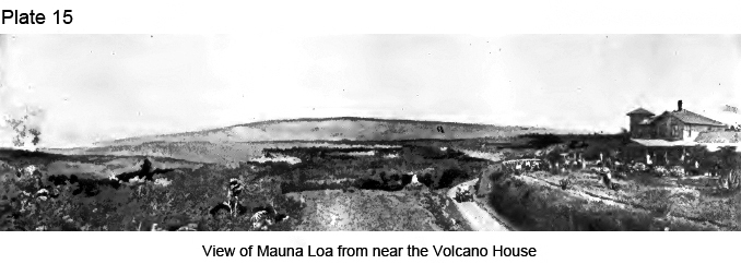
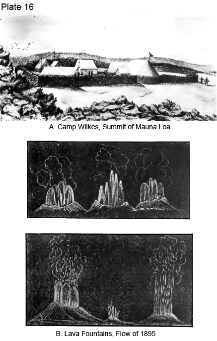
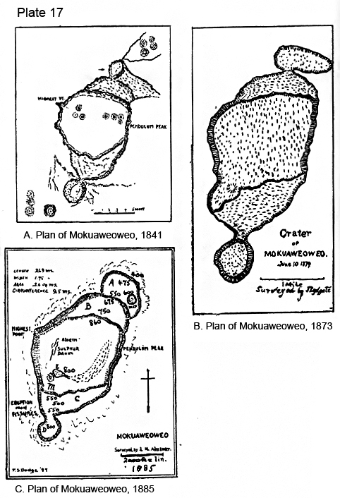
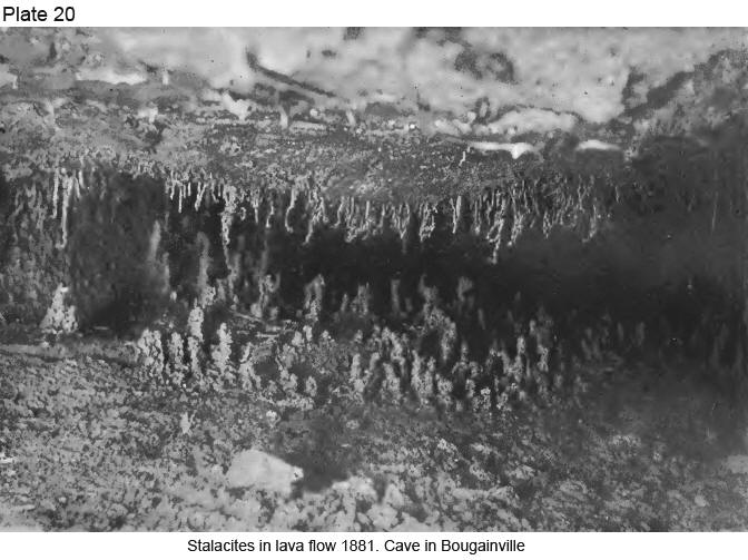
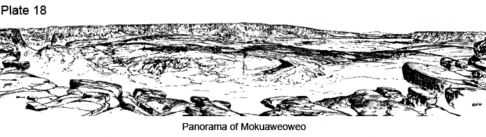
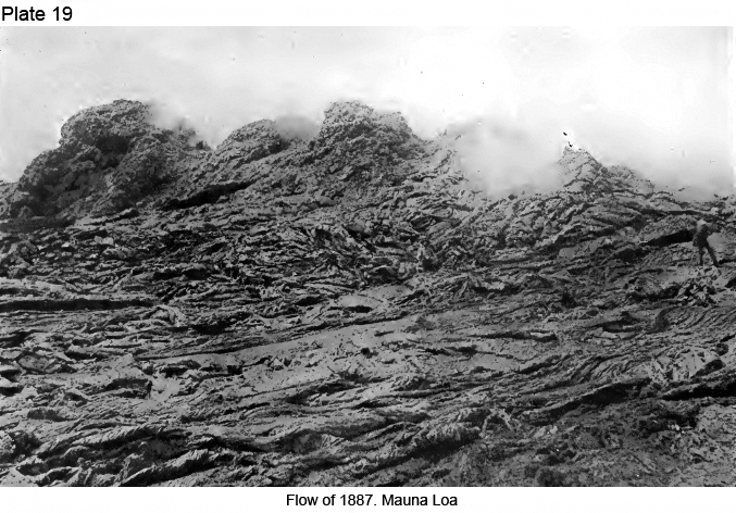
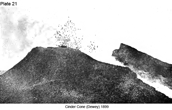
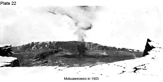
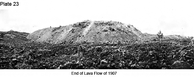
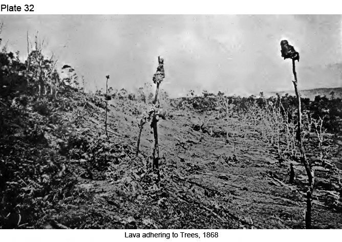
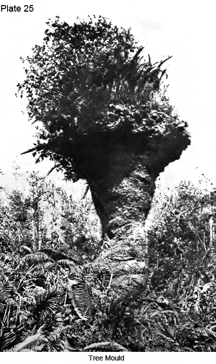
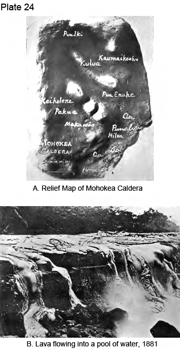
|
|
|
|
|
|
||
| History | Atlas | Culture | Language | Links |